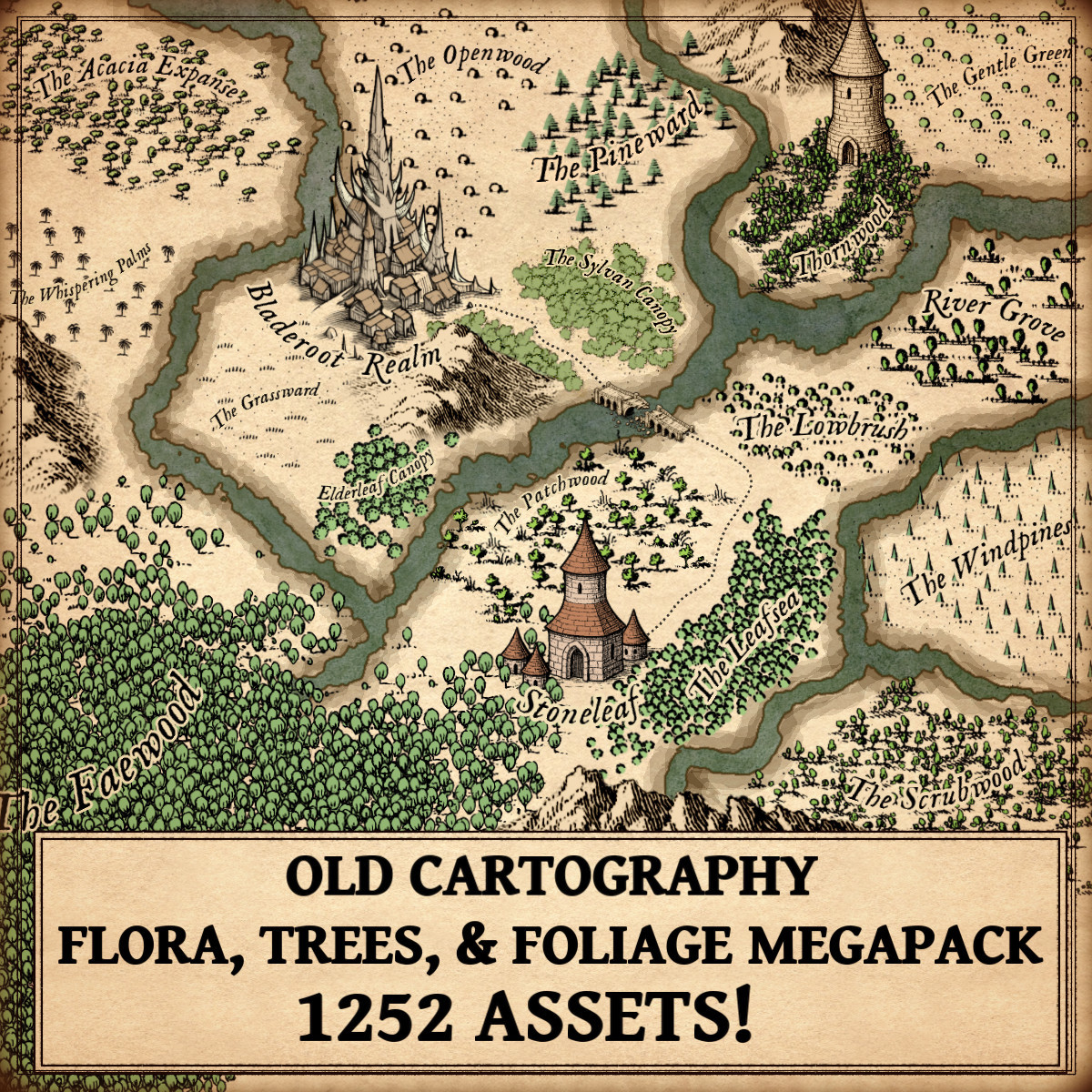
Trees, Flora, & Foliage – Old Cartography Assets Megapack
The Trees, Flora, & Foliage – Old Cartography Assets Megapack draws its strength from a long and venerable tradition. It does not merely offer visual elements for mapmaking; it echoes centuries of cartographic practice in which trees, vegetation, and textured ground were essential tools for understanding the world. Rooted in antique aesthetics and symbolic clarity, this collection belongs to the lineage of maps where nature was not background decoration, but meaning itself.
Discover the Trees, Flora, & Foliage – Old Cartography Assets Megapack here :
From the earliest hand-drawn maps scratched onto parchment to the richly illustrated fantasy maps of today, vegetation has always played a central role in cartography. Trees, oaks, fir trees, palms, acacias, bushes, soil textures, meadow grass, brushland, and top-down forests are not mere ornaments. They are symbols of climate, culture, economy, and myth, carefully placed to speak a visual language older than modern geography itself.
In the tradition of antique mapmaking, land was never empty. Every forest breathed meaning, every grove hinted at resources or danger, and every textured soil told a silent story of fertility or desolation. Modern Wonderdraft assets and cartography assets rooted in old cartographic styles naturally inherit this deep visual heritage, especially when used to build convincing and immersive fantasy worlds.
The Origins of Vegetation Symbols in Antique Cartography Assets
Ancient and medieval cartographers did not aim for scientific realism. Instead, they sought legibility, symbolism, and narrative clarity. Trees were drawn not as individuals, but as types: oak forests for temperate lands, fir trees for cold or mountainous regions, palms and acacias for distant, sun-burned realms.
A clear example can be found in Ptolemaic maps (2nd century AD), where wooded regions were marked with repeated tree symbols to distinguish fertile lands from deserts. Later, medieval mappaemundi, such as the Hereford Mappa Mundi (c. 1300), used stylized vegetation to frame the inhabited world and emphasize divine order in nature.
These early cartography assets established a visual grammar that still defines how fantasy map icons communicate terrain today.
Oaks, Fir Trees, Pines, and the Cultural Meaning of Forest Types
Oaks: Power, Ancestry, and Civilization
In European tradition, oak forests symbolized permanence, lineage, and authority. Roman maps and later Renaissance atlases often placed oak-heavy woodlands near settlements, roads, and political centers. In fantasy maps, oak tree clumps and woods continue this role, signaling stable kingdoms, ancient druidic sites, or regions settled for generations.
Fir and Pine Trees: Wilderness and the Unknown
Fir trees and pine forests, common in Alpine and Northern European maps such as Sebastian Münster’s Cosmographia (1544), represented harsher climates and untamed lands. Their sharp, vertical silhouettes became visual shorthand for cold winds, high altitudes, and perilous journeys, an essential cue still widely used in modern fantasy map icons.
Palm Trees, Acacias, and the Exoticism of Distant Lands
Palm trees and acacias entered Western cartography through trade routes, conquest, and imagination. Portolan charts and early maps of Africa and the Near East, such as those by Abraham Cresques in the 14th century, used palms to indicate unfamiliar climates and economically valuable regions.
In fantasy maps, palms and savanna trees instantly convey heat, distance, and otherness. Landscapes dotted with acacias suggest open horizons, nomadic cultures, and fragile ecosystems. These elements remain vital Wonderdraft assets for worldbuilders seeking clarity and atmosphere without relying on written explanations.
Bushes, Brushland, and Low Vegetation as Functional Cartography Assets
Not all landscapes are forests, and antique mapmakers understood this well. Bushes, brushland, and low vegetation were used to indicate transitional terrain, lands neither fully wild nor fully cultivated.
On Renaissance military maps, brushland often marked areas suitable for ambush or difficult movement. In fantasy cartography, bushland flora and trees help define biome boundaries, soften harsh transitions, and add realism without overwhelming the composition.
These subtle cartography assets are essential for visual rhythm and believable geography.
Soil Texture, Dots, and the Language of the Ground
One of the most understated yet powerful tools in antique cartography is soil texture, often represented by small dots, stippling, or scattered marks. These textures appear in early cadastral maps, medieval travel charts, and even ancient Roman land surveys.
Soil texture serves several purposes:
- It fills empty space without overpowering the map
- It indicates aridity, fertility, or wasteland
- It creates depth and visual hierarchy beneath trees and vegetation
In fantasy maps, dotted soil textures beneath forests or meadows reinforce the continuity of the terrain. They are silent yet essential fantasy map icons, grounding imaginary worlds in historical visual logic.
Meadow Grass and the Idealized Landscape
Meadow grass appears frequently in early modern maps depicting “civilized” lands. These open, lightly textured areas suggested agriculture, safety, and prosperity. Dutch Golden Age cartographers such as Joan Blaeu used grassy plains to contrast dense forests and mountainous regions.
In fantasy cartography, meadow grass provides breathing space. It frames forests, supports settlements, and creates visual balance, an artistic necessity inherited directly from antique traditions.
Top-Down Trees and the Evolution of Perspective
While most antique maps relied on oblique or symbolic views, some late medieval and Renaissance works experimented with top-down representations for clarity, especially in city plans and regional surveys.
Modern fantasy maps adopt top-down trees and foliage to improve readability at smaller scales. This evolution does not break tradition, it refines it. These elements preserve the antique aesthetic while embracing functional clarity, making them indispensable Wonderdraft assets for contemporary mapmakers.
Vegetation Clumps, Forest Masses, and Visual Storytelling
Antique cartographers rarely scattered trees at random. Forests appeared as intentional masses, guiding the eye along roads, rivers, and borders. Vegetation clumps were compositional tools as much as geographic indicators.
In fantasy maps, oak forests, pine woods, Mediterranean woodland vegetation, rounded shrubs, and low vegetation serve the same narrative function. They guide the viewer, suggest deep history, and imply unseen stories: lost roads, ancient battles, forgotten sanctuaries.
This is where cartography assets become art.
Why These Elements Are Both Useful and Decorative
Vegetation symbols endure because they fulfill three functions at once:
- Utility – conveying terrain, climate, and movement
- Culture – reflecting myths, economies, and worldviews
- Decoration – enriching the map as an illustrated object
Antique maps were not merely tools; they were precious objects. Fantasy maps follow the same philosophy. Carefully designed fantasy map icons for trees, flora, and foliage honor this legacy while empowering modern creators.
A Living Tradition in Modern Wonderdraft Assets
The visual language of trees, bushes, soil textures, meadow grass, brushland, and forests has survived centuries because it works. It is intuitive, symbolic, and endlessly adaptable.
The Trees, Flora, & Foliage – Old Cartography Assets Megapack firmly belongs to this tradition, offering a coherent collection of vegetation forms rooted in historical cartography. It does not invent a new language, it refines an ancient one.
For fantasy cartographers, worldbuilders, and storytellers, these Wonderdraft assets and .png cartography assets are not just tools. They are the continuation of a craft that once mapped the known world, and now maps imagined ones.