Introduction: Why Slavic Aesthetics Matter in Fantasy Map Making
In the world of fantasy map making, visual language is everything. Long before modern cartography prioritized scale and accuracy, antique maps relied on fantasy map icons and symbolic representations to communicate culture, power, danger, and belief. Among these traditions, Slavic-inspired settlements and landscapes occupy a unique place—both historically grounded and visually evocative.
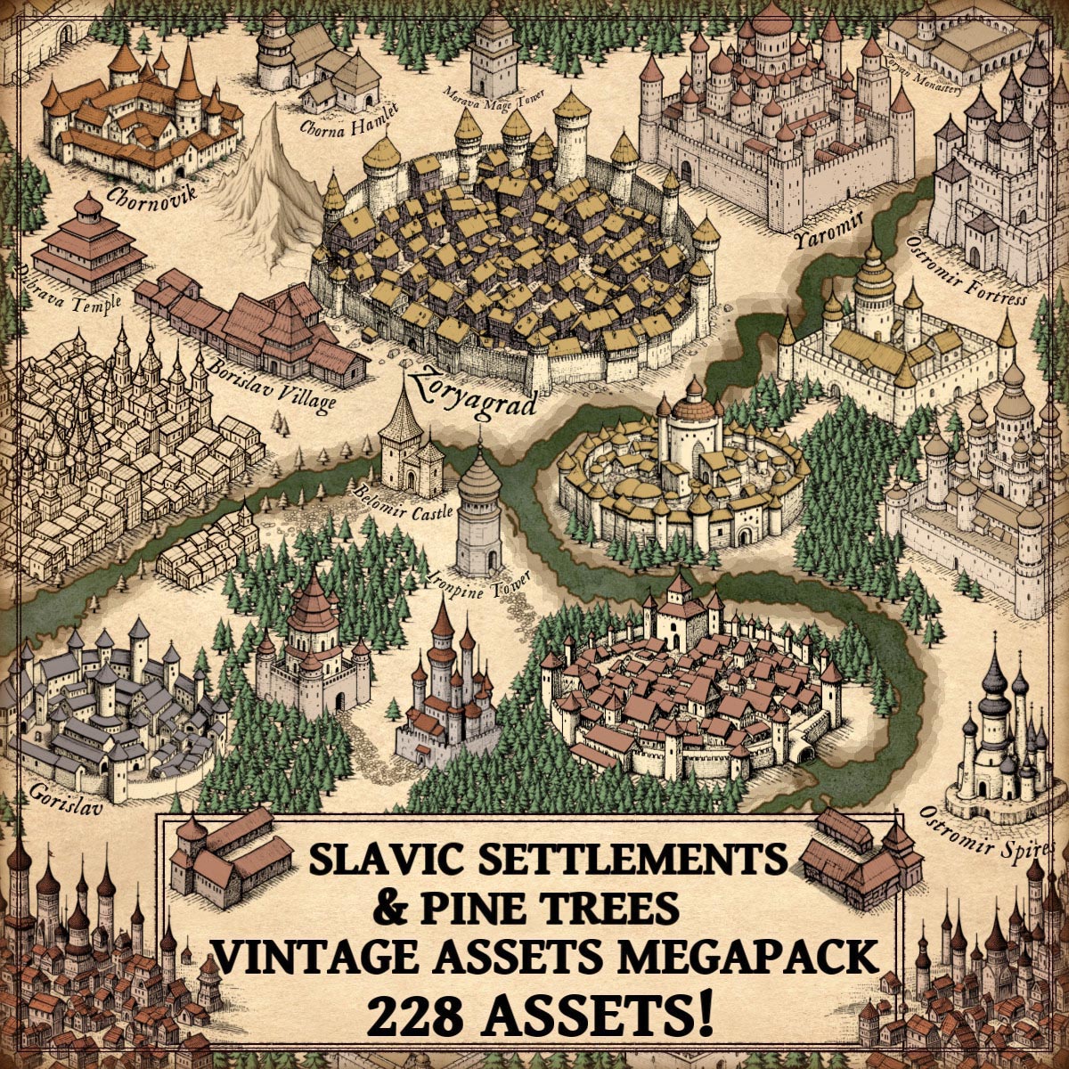
The Fortified Slavic Settlements, Towns, Castles, & Pine Trees – Vintage Assets Megapack draws directly from this legacy. Inspired by medieval and early modern cartography, the assets in the pack echo the same principles found in real antique maps: clarity, symbolism, hierarchy, and artistic storytelling. These wonderdraft assets are not merely decorative; they are functional heirs to centuries of cartographic practice.
Discover the Fortified Slavic Settlements, Towns, Castles, & Pine Trees – Vintage Assets Megapack here :
Slavic Settlements as Core Fantasy Map Icons in Fantasy Map Making
Slavic settlements form the structural backbone of many historical and fictional maps. From early medieval villages to organized towns, Slavic societies developed settlement patterns shaped by forests, rivers, and communal defense.
On antique maps, settlements were rarely drawn to scale. Instead, they were represented through:
- Compact clusters of houses
- Repeated architectural motifs
- Simplified silhouettes readable at a distance
This megapack follow the same logic. Each Slavic settlement icon conveys population level, permanence, and importance at a glance. In fantasy map icons, these symbols allow mapmakers to build believable regions without overwhelming the composition.
Historically comparable examples include:
- The city vignettes in the Nuremberg Chronicle (1493)
- Early Eastern European regional maps where towns appear as emblematic miniatures
These assets translate that tradition directly into modern vintage cartography assets for fantasy worlds.
Fortified Slavic Towns in Vintage Cartography Assets and Medieval Fantasy Maps
Fortified Slavic towns—often known historically as gords or grads—were central to political and military life. Built with timber walls, earthworks, and later stone fortifications, they guarded trade routes and borders.
In antique cartography, fortified towns were emphasized visually:
- Thick walls
- Towers multiplied beyond reality
- Circular or geometric layouts
Maps such as Olaus Magnus’ Carta Marina (1539) demonstrate this exaggeration clearly. Fortifications were symbolic first, accurate second.
The fortified towns in this pack embrace this same visual philosophy. As fantasy map symbols, they instantly communicate:
- Strategic importance
- Military control
- Regional authority
For fantasy map making, these wonderdraft assets provide visual hierarchy—guiding the viewer’s eye across the map.
Slavic Towns, Hamlets, and Villages as Everyday Fantasy Map Icons
Not all power lies behind walls. Slavic hamlets and villages represent the daily life of the land: farmers, woodcutters, traders, and craftsmen.
Historically:
- Villages were loosely organized
- Houses were primarily wooden
- Roofs and layouts reflected climate and local resources
Antique maps often depicted such settlements as small clusters of buildings, sometimes no more than a symbol. This abstraction is faithfully preserved in the megapack, making these assets ideal fantasy map icons for:
- Filling rural spaces
- Indicating population spread
- Supporting narrative realism
In vintage cartography assets, these elements serve as connective tissue between cities and wilderness.
Slavic Castles, Fortresses, and Citadels as Fantasy Map Symbols of Power
Slavic castles and fortresses mark the transition from tribal organization to feudal authority. From early hillforts to later stone complexes, they symbolized rulership, defense, and permanence.
Historical counterparts include:
- Wawel Castle in Kraków
- Early fortified centers of Kievan Rus
In antique maps, castles were often oversized and idealized. Their purpose was symbolic dominance rather than architectural precision.
The castles, fortresses, and citadels in this megapack continue this tradition. As fantasy map icons, they:
- Anchor political regions
- Serve as narrative focal points
- Reinforce medieval atmosphere
These wonderdraft assets excel at translating authority into visual form.
Slavic Cities and Dense Urban Medieval Blocks in Fantasy Map Making
Large Slavic cities developed around trade, religion, and defense. Dense housing, narrow streets, and layered fortifications defined their character.
Antique maps frequently represented cities as:
- Dense masses of rooftops
- Repeated towers and domes
- Highly stylized urban blocks
This megapack’s dense urban medieval city blocks reflect those conventions precisely. In fantasy map making, they allow cartographers to suggest urban complexity without sacrificing clarity—an essential trait of effective vintage cartography assets.
Slavic Temples, Monasteries, and Sacred Architecture in Fantasy Map Icons
Spiritual geography was as important as political geography. Before Christianization, Slavic cultures maintained sacred temples and ritual spaces; later, monasteries became centers of learning and influence.
Antique maps routinely emphasized religious structures, often regardless of their actual size. This tradition is visible in:
- Medieval pilgrimage maps
- Early ecclesiastical atlases
The Slavic temples and monasteries in the pack act as fantasy map symbols for:
- Faith systems
- Cultural identity
- Ideological influence
They enrich fantasy worlds with layers of belief and history.
Gatehouses, Watchtowers, Mage Towers, and Defensive Infrastructure
Infrastructure elements—gatehouses, watchtowers, and towers—were critical to medieval landscapes. On antique maps, such features often appeared as standalone symbols marking borders, roads, or dangerous zones.
In fantasy cartography, mage towers inherit the same symbolic role once held by keeps and signal towers. The assets in this pack respect antique visual logic, ensuring stylistic cohesion across realistic and fantastical elements.
As fantasy map icons, they guide movement, suggest danger, and support storytelling.
Pine Trees and Forest Landscapes in Vintage Cartography Assets
Forests defined the Slavic world. Vast pine woodlands shaped settlement patterns, warfare, and mythology.
Antique cartographers represented forests through repeated tree symbols, not shaded terrain. Pines often signaled:
- Cold climates
- Untamed regions
- Natural borders
The pine trees in the pack fulfill exactly this role. They are not background decoration; they are cultural markers. In fantasy map making, they:
- Frame settlements
- Shape travel routes
- Enhance regional identity
These vintage cartography assets remain faithful to historical precedent.
Utility, Culture, and Decoration in Fantasy Map Icons
Antique maps balanced three essential purposes:
- Utility — conveying information clearly
- Culture — expressing identity and worldview
- Decoration — engaging the viewer
The Fortified Slavic Settlements, Towns, Castles, & Pine Trees – Vintage Assets Megapack succeeds because it respects all three. Every asset is:
- Readable at map scale
- Historically inspired
- Artistically cohesive
These wonderdraft assets are tools, but also storytelling instruments.
Conclusion: Slavic Heritage as a Foundation for Fantasy Map Making
Slavic-inspired fantasy map icons are not niche embellishments—they are foundational elements rooted in real cartographic history. By drawing from antique representations and medieval visual logic, this asset pack allows creators to build worlds that feel authentic, layered, and timeless.
In continuing the traditions of antique maps, these vintage cartography assets do what the best fantasy cartography has always done:
transform geography into narrative, and symbols into stories.