Posted on

The Forgotten Art of the Insectoid: From Ancient Cartography Assets to Wonderdraft Assets

insectoid settlements, fantasy map making, Wonderdraft assets, insectoids, cartography assets, fantasy map icons, hives, nests

Exploring the Role of Insectoid Settlements, Hives, and Nests in Maps — Featuring the Insectoid Settlements – Vintage Assets Megapack for Wonderdraft

Throughout the long history of cartography, mapmakers have used symbols not only to guide travelers but to tell stories. Among the most fascinating and often overlooked visual traditions are those representing insectoid settlements, hives, lairs, and nests — motifs that appear in both antique maps and modern fantasy map making. These cartography assets, recreated in the Insectoid Settlements, Hives, Nests, & Colonies – Vintage Assets Megapack, revive a forgotten visual language that once expressed fear, fascination, and mystery toward the hidden world of insects.

BUY AND DOWNLOAD The Insectoid Settlements, Hives, Nests, & Colonies (Insectoids, arachnids, eggs, & more) – Vintage Assets Megapack here :

1. Ancient and Medieval Origins of Insectoid Imagery in Cartography

In the early eras of mapmaking — from Ptolemaic charts to the illuminated manuscripts of the Middle Ages — insects and arachnids were rarely literal depictions of fauna. Instead, they were symbolic creatures marking unknown or “forbidden” lands. Just as sea serpents guarded the uncharted oceans of the Carta Marina (1539) or the Hereford Mappa Mundi (c.1300), monstrous beetles, worms, and burrowing shapes sometimes appeared near deserts, caves, or ruins, suggesting infestation, decay, or divine punishment.

These fantasy map symbols were both warnings and metaphors. Insects, seen as agents of transformation, represented the volatile nature of unexplored territories. Burrows and pits echoed humanity’s fear of the subterranean — the unseen spaces beneath kingdoms and civilizations. Some early Islamic and Chinese cartographic manuscripts even featured hive-like structures to indicate subterranean cities or clustered dwellings, eerily similar to insectoid colonies depicted in modern fantasy maps.

2. The Cultural Meaning of Hives, Lairs, and Egg Clusters

The use of hives, nests, and egg clusters on maps was deeply tied to human perceptions of order and chaos. Beehives, for example, symbolized industriousness and divine architecture — a natural geometry that medieval monks associated with heavenly design. In contrast, spider lairs and worm burrows symbolized corruption or the demonic underworld.

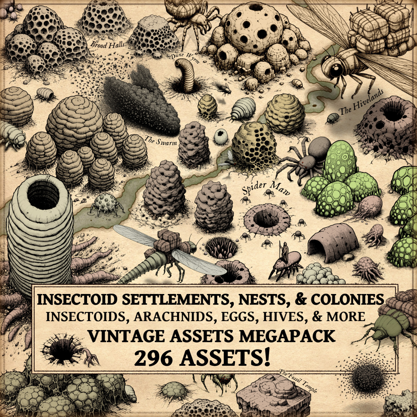
In the context of fantasy map making, these same dualities persist. A hive might represent an alien civilization with perfect social structure, while a crater nest or egg sac can signify spreading corruption or plague. The “Insectoid Settlements” asset pack captures this range — from organic hive towers and cocoon chambers to sprawling burrows and larvae clusters — allowing map artists to visually express both civilization and contagion.

3. The Artistic Legacy in Fantasy Map Making

Modern creators, especially those using tools like Wonderdraft, have revived antique cartographic aesthetics through vintage-style fantasy map icons. The Insectoid Settlements, Hives, Nests, & Colonies – Vintage Assets Megapack continues this tradition by merging historical artistry with modern usability.

The pack displays an extraordinary variety of assets:

  • Insectoids and arachnids: from hulking beetles to agile spiders and mounted insectoid figures.
  • Flying insectoids: dragonflies, giant flies, and swarming species rendered in motion with aerial shadows.
  • Organic architecture: hive domes, brood pods, tunnels, pits, burrows, and hive towers recalling natural citadels.
  • Larval and parasitic lifeforms: eggs, sacs, clusters, and worm-like burrowers that evoke the life cycle of alien ecosystems.

Each of these cartography assets is designed in a vintage engraving style, echoing the textures of 17th–18th century natural history prints. The linework and muted tones emulate aged parchment — a deliberate nod to maps from explorers like Athanasius Kircher, whose Mundus Subterraneus (1665) famously combined geology, biology, and myth.

4. Insectoid Colonies and the Psychology of the Unknown

The fascination with insectoid civilizations is more than aesthetic. In ancient and modern maps alike, these forms represent the psychological projection of the alien within the familiar. The hive is not just a structure; it is a metaphor for collective intelligence, for the overwhelming and organized “other.”

In Tolkien’s Middle-earth, the “Mirkwood Spiders” and their forest lairs carry echoes of this tradition. In the Warhammer universe, Tyranid hives and brood chambers form the backbone of alien cartography. Even in the Dungeons & Dragons cosmology, underground maps of the Underdark feature nesting burrows and insectoid colonies, showing how this visual lexicon migrated from historical imagination into fantasy design.

These fantasy map symbols function as storytelling devices: the viewer instantly senses danger, fecundity, or expansion. A cluster of eggs near a swamp or crater signals life spreading uncontrollably — a cartographic shorthand for tension and threat.

5. The Decorative and Functional Purpose of Insectoid Map Icons

Historically, decoration in maps was never merely ornamental. Every embellishment had a purpose — to attract the eye, guide interpretation, and invoke emotion. The same is true for fantasy map icons in modern digital cartography.

In Wonderdraft map making, icons such as insectoid settlements, hives, or pits serve both narrative and compositional roles:

  • Narrative: indicating regions dominated by swarms, brood queens, or hive-minded species.
  • Compositional: providing textural variety, balancing visual density, and breaking the monotony of natural terrain.

By using these Wonderdraft assets, cartographers can emulate the layered symbolism of antique maps — where every mark on the parchment was a story, and every cluster of dots hinted at the unknown.

6. A Revival of Organic Cartography

The Insectoid Settlements, Hives, Nests, & Colonies – Vintage Assets Megapack is more than a design resource. It is a revival of organic cartography — a reminder that fantasy worlds, like the natural one, thrive on cycles of growth, decay, and rebirth.

The Megapack assets show the intricate diversity of forms:

  • Brood pods, organic ruins, and hive towers evoke long-lost civilizations.
  • Termite mounds and burrowing worms give a sense of subterranean life.
  • Hive queens, insectoid porters, and flying swarms illustrate hierarchy and labor, mirroring historical allegories of empire and order.

In this sense, these assets are educational tools. They teach us to read maps as living organisms — dynamic, evolving, and filled with hidden motion beneath the surface.

7. From History to Fantasy: The Timeless Allure of the Hive

From the sacred beehives carved on Egyptian temple walls to the monstrous ant cities of modern fantasy, the image of the insectoid settlement has never left our imagination. It bridges myth, biology, and architecture — a symbol of how societies, whether human or alien, organize themselves in the face of chaos.

By studying antique depictions and applying them to fantasy map making, today’s artists rediscover an ancient truth: that maps are not just guides through space, but through imagination. The Insectoid Settlements, Hives, Nests, & Colonies – Vintage Assets Megapack transforms that tradition into a visual language — one that speaks in silk, soil, and swarm.

Final Thoughts

Whether you are a historian, an artist, or a digital cartographer, these cartography assets remind us that fantasy maps inherit a deep artistic lineage. What once decorated the margins of medieval manuscripts now thrives in the digital realms of Wonderdraft — the same fascination with pattern, life, and mystery rendered anew.

Through these assets, the hive lives on — not just as a structure, but as a metaphor for all the unseen civilizations buzzing beneath the surface of the world.

Posted on

Ramparts in Fantasy Maps: From isometric castle walls to Wonderdraft assets

In both ancient cartography and fantasy map making, the depiction of ramparts, city walls, and defensive structures has always been more than mere decoration. These symbols tell stories of protection, power, and civilization itself. From the crenellated enclosures of medieval towns to the stylized fortifications of modern Wonderdraft assets and fantasy map icons, the way walls are drawn reflects both history and imagination.

The new Modular Medieval Ramparts & Castle Walls – Vintage Assets Megapack celebrates this rich tradition by bringing to life the artistic language of ancient and fantasy maps. Its hand-drawn style echoes the texture and charm of antique cartography while offering modern creators a vast library of cartography assets to build immersive worlds.

BUY AND DOWNLOAD The Modular Medieval Ramparts & Castle Walls – Vintage Assets Megapack here :


Walls as Borders and Symbols in Ancient Cartography

Long before satellite imagery and GIS data, maps were not purely geographic—they were conceptual. The Babylonian World Map (6th century BCE), etched on clay, is one of the earliest known examples: the world surrounded by a circular ocean, cities marked as fortified dots. The walls drawn around Babylon are not architectural records but symbols of order against chaos.

Similarly, in medieval mappa mundi—such as the famous Hereford Mappa Mundi (c. 1300)—Jerusalem sits encircled by massive ramparts, representing the divine center of the world. These circular walls are less about defense and more about sanctity and separation: the wall as the line between the holy and the profane.

Later, Renaissance cartographers like Sebastian Münster and Abraham Ortelius refined the visual grammar of fortification. Their maps of cities such as Venice or Nuremberg show detailed bastions and geometric ramparts—symbols of engineering pride as much as military might. Every line and crenelation was a proclamation of civilization’s control over the land.


City Walls and the Language of Fantasy Map Icons

When we shift to fantasy cartography, these traditions endure. Every fantasy map maker knows the satisfying logic of drawing a walled city—its circular perimeter promising safety from monsters, its gates marking trade and adventure. In worlds like Tolkien’s Middle-earth, Minas Tirith and Helm’s Deep are iconic examples of ramparted architecture, where geography and storytelling intertwine.

In Game of Thrones, George R.R. Martin’s King’s Landing and The Wall itself extend this visual heritage: fortifications not only divide nations but define entire mythologies. The map of Westeros—engraved with mountains, castles, and walls—owes much to the aesthetics of medieval European mapmaking.

Today, tools like Wonderdraft and other digital platforms continue this tradition. Through packs like the Modular Medieval Ramparts & Castle Walls – Vintage Assets Megapack, fantasy mapmakers can recreate these timeless symbols with authenticity and flexibility—choosing from medieval, gothic, eastern, Aztec, or Middle Eastern architectural styles to match the lore of their worlds.


The Practical and Cultural Role of Rampart Representation

Historically, the inclusion of ramparts and walls in maps served both utilitarian and symbolic functions.

  • Defensive visualization: Early military engineers—like those of Vauban’s France—used detailed rampart plans to organize sieges, fortify cities, or project imperial power. The accuracy of wall representation could determine victory or defeat.
  • Cultural identity: In ancient maps, walls were marks of prestige. A city without walls was not a city; it was wilderness. The Greek term polis implied both community and enclosure.
  • Decorative artistry: In illuminated manuscripts and portolan charts, ramparts framed the miniature world with rhythmic, ornamental lines. They gave texture and weight to the map, guiding the eye and evoking grandeur.

In modern fantasy map making, this duality remains. Ramparts not only define territory—they add visual depth and narrative significance. A ruined wall suggests history; a massive bastion hints at a bygone war. Even the placement of a gate can tell the story of trade, pilgrimage, or invasion.


A Tribute to Historical Styles: The Modular Medieval Ramparts Megapack

The Modular Medieval Ramparts & Castle Walls – Vintage Assets Megapack revives this centuries-old visual language with an artistic nod to antique map engraving. Designed for fantasy cartographers, it provides an extensive collection of modular pieces that can be combined to build believable fortified landscapes.

The pack includes:

  • Ramparts, castle walls, and ruined walls for every architectural taste—from western medieval to eastern or Aztec motifs.
  • Defensive towers, gatehouses, bastions, and watchtowers, allowing creators to illustrate strongholds of any scale.
  • Decorative elements such as gargoyles, shields, flags, stone ornaments, and palisades to enrich the storytelling texture of the map.
  • Natural and civic additions—trees, farms, ponds, churches, and medieval houses—that integrate the fortified city into its surrounding world.

The visual tone imitates the sepia and ink-washed quality of old world cartography, making these fantasy map icons ideal for both historical maps and fantastical realms. Whether you are recreating Constantinople’s Theodosian Walls, the ruins of an ancient Aztec temple city, or an entirely invented fortress kingdom, these assets provide both precision and atmosphere.


The Enduring Appeal of Fortifications in Fantasy Cartography

Why do walled cities continue to fascinate us? Perhaps because they embody the human instinct to draw boundaries—to separate safety from danger, civilization from wilderness, the known from the unknown.

In ancient times, this was a matter of survival. In mapmaking, it became a language of form. In fantasy, it has become a language of emotion. When a reader or player sees a crenellated line on a parchment map, they instantly understand: “Here lies a city of strength.”

Thus, the artistic tradition of rampart representation unites millennia of human creativity—from Babylonian clay tablets to digital fantasy maps. And in tools like Wonderdraft or other modern cartography asset packs, that heritage continues to evolve, allowing every creator to become both historian and world-builder.


Conclusion

The Modular Medieval Ramparts & Castle Walls – Vintage Assets Megapack is not merely a collection of images—it is a bridge between ancient cartographic artistry and the modern imagination. By reviving the timeless symbols of defense, order, and beauty, it empowers creators to craft maps that feel truly alive—rooted in history, yet rich in fantasy.

Whether you are designing a fortified city for a tabletop campaign, illustrating an ancient empire, or mapping a fictional continent, these fantasy map making tools give you the vocabulary of ages past, rendered with modern precision.

Walls may divide lands, but in the realm of cartography, they unite centuries of art, storytelling, and design.

Posted on

Timeless Cartography Assets: The Role of Top-Down Towns, Castles, and Cities

top-down assets, Vintage cartography assets, fantasy map icons, towns, cities, buildings, Wonderdraft, Inkarnate

Maps have always been more than navigation tools. They are storytelling devices, cultural artifacts, and works of art. One of the most fascinating features of both historical and fantasy cartography is the use of top-down representations—miniature towns, villages, castles, piers, temples, and city walls that condense culture and history into symbols.

With modern Wonderdraft assets such as the Top-down towns, castles, villages, & more pack, today’s creators can continue this tradition, bringing life and depth to their fantasy maps while echoing centuries of cartographic practice.

BUY AND DOWNLOAD The Old Cartography top-down towns, castles, villages, & more  Assets Megapack here :

Grid-Planned Towns and Organic Settlements: Classic Fantasy Map Icons

Cartography has always revealed the contrast between organic towns and grid-planned cities.

  • Organic settlements, especially in medieval Europe, grew around castles, rivers, and trade roads. Their winding streets and irregular clusters reflected centuries of adaptation to local geography.
  • Grid-planned cities, by contrast, symbolize order and authority. While rooted in Roman military layouts, this approach became especially prominent in the 18th and 19th centuries in the United States. Cities such as Philadelphia and many Midwestern towns followed strict rectilinear grids, embodying Enlightenment ideals and practical governance.

This duality—wild frontier villages versus orderly planned colonies—remains central in fantasy storytelling. With the right fantasy map icons, you can bring this same historical authenticity into your own worlds.


Cartography Assets in the 18th and 19th Centuries

The Enlightenment and Industrial Age reshaped cartography. In the 18th and 19th centuries, maps were not only decorative—they became precise instruments of power, trade, and expansion.

  • Military maps showed bastioned forts, walls, and ramparts, emphasizing defense.
  • Colonial maps marked gridded towns to project administrative control.
  • Commercial atlases depicted piers, harbors, and watermills, highlighting networks of commerce.

These standardized cartography assets made it possible to instantly read a landscape: every castle spoke of power, every bridge of trade, every temple of belief.


Functional and Symbolic Roles of Fantasy Map Icons

What makes top-down symbols so enduring is their dual function: they are both practical and symbolic.

  • Bridges show strategic crossings and economic lifelines.
  • Temples and churches act as cultural and spiritual centers.
  • Castles and forts embody strength, protection, and political dominance.
  • Mines, watermills, and piers reveal resources, labor, and prosperity.

Just as 19th-century engineers used icons to control colonial territories, today’s worldbuilders use fantasy map icons to create depth, history, and narrative.


Wonderdraft Assets: Timeless and Decorative

From Enlightenment atlases to digital fantasy maps, top-down cartography has proven timeless. These representations are not bound to a single period—they evolve with culture and remain relevant today.

Their beauty lies in versatility: they orient the reader, provide context, and embellish a map with life. A well-placed fortress or walled city transforms a flat map into a living world.

The Top-down towns, castles, villages, & more collection of Wonderdraft assets allows modern creators to combine utility and artistry. These tools produce maps that are not only functional but visually captivating.


Fictional Resonances: From Fantasy Maps to Storytelling

Modern fantasy inherits these traditions:

  • Tolkien’s Minas Tirith, rising as a fortified emblem.
  • Martin’s Winterfell and King’s Landing, echoing medieval strongholds.
  • Countless tabletop RPG maps, where towns, villages, and forts serve both immersion and gameplay.

These examples prove that symbolic cartography is not just history—it is a living art form.


Conclusion: Cartography Assets for Worldbuilders

From grid-planned American cities to medieval strongholds, from Enlightenment atlases to modern fantasy campaigns, top-down cartography remains a universal language. Each bridge, rampart, or temple encodes both utility and meaning.

The Top-down towns, castles, villages, & more pack of fantasy map icons is more than a toolkit—it is a continuation of centuries of symbolic cartography. By using these cartography assets, you bridge history and imagination, building maps that are useful, decorative, and deeply cultural.

Posted on

Mediterranean Cartography Assets: Fortified Cities, Ports, Villages, Vineyards, and Wonderdraft Assets for Fantasy Maps

Fantasy map icons, Wonderdraft assets, Mediterranean ports, towns, vineyard, vines, fishing villages, cartography assets

From medieval cartography assets in antique atlases to modern fantasy map icons used in roleplaying games, the Mediterranean world has always been represented through powerful imagery: walled cities on cliffs, busy harbors, Roman arenas, spiral towers, and vineyard-covered hills. These elements are not merely decorative—they are fantasy map symbols of culture, economy, and identity.

The Mediterranean Settlements, Ports, Cities, Villages, Vineyards, Buildings – Vintage Assets Megapack embraces this tradition. Designed as high-quality Wonderdraft assets, it provides mapmakers with an authentic visual language that echoes antique maps while serving modern fantasy cartography.

BUY AND DOWNLOAD The Mediterranean Settlements – Vintage Assets Megapack here :


Fortified Cities: Anchors of Power in Cartography Assets

Throughout history, fortified cities have been among the most prominent cartography assets. Medieval maps such as the Hereford Mappa Mundi (c. 1300) placed Jerusalem at the symbolic center, not for its geographic accuracy but for its cultural weight. Portolan charts of the Mediterranean also emphasized Genoa, Venice, and Constantinople as towering walled cities, dominating both sea and land.

In fantasy cartography, these fantasy map symbols instantly communicate strength, political intrigue, and cultural centrality. The Megapack’s fortified cities and towns, inspired by Tuscan citadels and Dalmatian fortresses, allow creators to anchor their maps with centers of history, trade, and storytelling.


Ports and Fishing Villages: Essential Fantasy Map Icons

Ports were the lifeblood of the Mediterranean. Ancient Roman itineraries recorded harbors meticulously, while Venetian cartographers exaggerated coastal cities to highlight maritime trade. Fishing villages—clusters of huts and small boats—appeared as humble yet vital symbols of subsistence.

The Megapack enriches maps with fantasy map icons of fishing villages, fortified ports, and fishing boats. These are indispensable cartography assets for campaigns set in worlds of piracy, commerce, and naval exploration. A single barque in a harbor can spark stories of smugglers, merchant guilds, or seaborne kingdoms.


Hilltop Villages and Mediterranean Settlements

The Mediterranean is famous for its hilltop villages, from the whitewashed towns of Andalusia to the fortified borghi of central Italy. Their elevation offered both protection and identity: villages as beacons above the land.

Historical cartographers like Piri Reis (16th century) often depicted settlements perched on stylized hills, emphasizing their dominance. The Megapack’s hilltop villages and hamlets bring this tradition to fantasy mapping, providing Wonderdraft assets that naturally blend geography with storytelling.


Roman Villas: Symbols of Aristocracy and Culture

Roman villas were more than luxurious estates—they were symbols of power, refinement, and connection to the land. Antique maps of Italy, as well as Renaissance engravings, often highlighted villas to showcase noble estates and agricultural wealth.

The Megapack includes elegant villa structures as fantasy map icons, evoking grandeur and continuity with the classical past. On fantasy maps, a villa may mark a patrician’s estate, a monastery, or the headquarters of a secret order. These cartography assets do not just place buildings—they evoke entire lifestyles.


Arenas and Hippodromes: Theaters of Spectacle

Among the most iconic monuments of the Mediterranean are the Roman arenas, amphitheaters, and hippodromes. Structures such as the Colosseum in Rome or the Hippodrome of Constantinople were more than entertainment venues: they were symbols of imperial authority, civic unity, and collective memory.

Antique maps and city views—such as Braun and Hogenberg’s Civitates Orbis Terrarum (1572)—often included these monumental arenas, placing them at the heart of their cities. They were not drawn to scale but to impress, to remind viewers of the spectacle and grandeur of urban life.

The Megapack brings these traditions into the fantasy realm with detailed Wonderdraft assets of amphitheaters and hippodromes. As fantasy map symbols, they suggest cultures of games, rituals, and political gatherings. A map marked with an arena is never neutral—it speaks of power, spectacle, and the stories of thousands who once gathered there.


Vineyards, Cypress Trees, and Stone Pines

Cultural landscapes were central to antique cartography. Cypress trees often symbolized sacred spaces, while stone pines, with their iconic umbrella canopies, became shorthand for the Mediterranean skyline. Vineyards, long associated with wealth and trade, were included in maps to highlight abundance and prosperity.

The Megapack’s inclusion of these elements allows cartographers to enrich their worlds with cultural depth. A vineyard marks agricultural wealth and trade routes. Cypress-lined avenues may signal cemeteries or temples. Stone pines add atmosphere, instantly evoking the sunlit coasts of Italy or Greece. These are more than decorative cartography assets—they are narrative markers of place and culture.


Arabic Villages: Mediterranean Crossroads

The Mediterranean was a crossroads of civilizations: Latin, Greek, Arab, Berber, and Jewish. Maps from the Islamic Golden Age, especially those of al-Idrisi (12th century), represented domed houses and cubic settlements that contrasted with European towns.

The Megapack reflects this with fantasy map icons of Arabic villages and towns. These cartography assets embody cultural diversity, encouraging fantasy creators to portray trade, migration, and cultural encounters. A domed village on a map is an invitation to explore stories of merchants, scholars, or desert pilgrims.


Minimalistic Crowds and Decorative Elements

Antique cartographers often populated maps with tiny figures: pilgrims, soldiers, merchants. These details animated maps, making them not just geographic but human. The Megapack’s minimalistic crowds follow this tradition, allowing mapmakers to breathe life into plazas, ports, and marketplaces with subtle fantasy map symbols.

Alongside spires, citadels, towers, and statues, these Wonderdraft assets transform maps into works of art, echoing the richness of antique cartography while serving modern worldbuilding.


Why These Fantasy Map Icons Matter

Maps have always been both functional and cultural. On one level, these cartography assets mark settlements, resources, and defenses. On another, they encode meaning: a fortified city signifies strength, an arena spectacle, a vineyard prosperity, a tower ambition.

In fantasy worlds, employing Wonderdraft assets like those in the Megapack places creators in the lineage of cartographers like Mercator or Piri Reis. Maps become more than guides—they become mirrors of civilizations and carriers of myth.


Conclusion: Antique Cartography Assets for Modern Fantasy Maps

The Mediterranean Settlements Megapack is more than a set of icons—it is a bridge between antique mapmaking and fantasy storytelling. With fortified cities, ports, fishing villages, Roman villas, arenas, hippodromes, vineyards, Arabic towns, and natural landscapes, it offers one of the most complete libraries of fantasy map icons and fantasy map symbols available.

For creators seeking high-quality Wonderdraft assets or historically inspired cartography assets, this collection ensures that every map is not only functional but a work of art, rich with history, culture, and narrative potential.

Posted on

Cartography assets : Exploring Temples and Shrines Through Fantasy Maps symbol

etching illustration of fantasy medieval temple, medieval fantasy assets, fantasy map, shrines, symbols,wonderdraft assets

Exploration of Sacred Sites: Temples and Shrines in Fantasy Cartography

Delving deeper into the enchanting realm of fantasy mapping unveils a rich tapestry of sacred sites, where temples and shrines stand as venerable landmarks steeped in myth and magic. In the fantastical landscapes depicted on maps, these places of worship transcend mere geographical features; they are portals to realms of divine intervention, epic quests, and mystical revelations.

BUY AND DOWNLOAD The Vintage Fantasy & Medieval Temples & Shrines – Assets Megapack here :

Sacred Nexus: Temples and Shrines as Narrative Anchors

In the intricate web of fantasy narratives, temples and shrines serve as pivotal points around which stories unfold. Whether they are ancient ruins reclaimed by nature or majestic citadels bustling with devout pilgrims, these sacred sites beckon adventurers with promises of untold treasures, hidden knowledge, or encounters with otherworldly beings.

Fantasy maps, adorned with the icons of temples and shrines, not only guide travelers on their quests but also ignite the imagination, hinting at the secrets and perils that await beyond the beaten path. Each depiction carries echoes of ancient myths and legends, inviting cartographers and readers alike to partake in the timeless dance between mortals and the divine.

Cultural Mosaic: Reflecting Diversity in Belief Systems

In the vibrant tapestry of fantasy worlds, temples and shrines mirror the kaleidoscope of cultural and religious diversity. From soaring cathedrals dedicated to holy fountains where wizards commune with nature spirits, these sacred spaces embody the varied beliefs and practices of fictional civilizations.

By incorporating temples and shrines into their maps, creators not only showcase the rich tapestry of fantasy cultures but also invite exploration of the nuanced relationships between mortals and deities. Each temple tells a story of devotion, sacrifice, or divine intervention, shaping the narrative landscape and enriching the tapestry of fantasy lore.

Mystical Symbols: Icons of Power and Mystery

At the heart of many fantasy maps lie the iconic symbols of sun and moon, imbued with mystical significance and symbolic resonance. These celestial emblems adorn temple facades, sacred artifacts, and ancient manuscripts, serving as potent reminders of cosmic forces and celestial cycles.

In the eyes of adventurers, these symbols represent not only navigational aids but also keys to unlocking hidden truths and unlocking the secrets of the universe. Whether they are etched into ancient stone or woven into tapestries depicting forgotten myths, sun and moon symbols evoke a sense of wonder and awe, fueling the imaginations of those who dare to chart the uncharted territories of fantasy realms.

Conclusion: Charting New Horizons in Fantasy Cartography

In the ever-expanding landscape of fantasy mapping, temples and shrines stand as beacons of hope, wisdom, and transcendence. Through their depiction on maps, these sacred sites invite adventurers to embark on epic journeys, forge alliances with divine beings, and unravel the mysteries of worlds both familiar and fantastical.

As we navigate the realms of imagination, guided by the icons of temples and shrines, we embark on a quest not only for treasures and glory but also for deeper understanding of the human condition and the eternal quest for meaning. In the end, it is not merely the destinations that matter but the journeys we undertake and the stories we weave along the way.

Posted on

Antiquity Maps Reimagined: Cartography Assets of the Roman Empire & Ancient Greece

wonderdraft assets, Roman Empire and Ancient Greece towns, settlements, arenas, temples, sanctuaries, fantasy map assets

I have always marveled at the representations of cities, arenas, settlements, and architectural styles inspired by the Roman Empire and ancient Greece. These elements play a pivotal role in shaping the worlds of fantasy maps. In this article, we’ll explore the historical and mystical aspects that influence the creation of fantasy maps, giving special attention to the architecture of the Roman and Greek ancient worlds.

BUY AND DOWNLOAD The Roman Empire & Ancient Greece Settlements and Towns – Vintage Assets Pack :

Architectural Styles of the Roman Empire and Ancient Greece

The architectural grandeur of the Roman Empire and the classical elegance of ancient Greece have left an indelible mark on the world of fantasy cartography. In these fantastical realms, cities sometimes mirror the grand cities of antiquity, and temples replicate the intricate designs of Roman and Greek places of worship. The style of buildings and structures from these civilizations significantly influences the aesthetics of these maps.

In the Roman tradition, we see the majesty of arenas, forts, palaces, and villas reflected in the fantasy world. The distinctive arches, columns, and domes of Roman architecture are often integrated into these maps, creating a sense of grandeur and historical richness. Settlements, villages, and towns often incorporate elements of Roman city planning and building styles.

Similarly, the enchanting architecture of ancient Greece, with its graceful columns, triangular pediments, and simplicity of design, finds its way into fantasy maps. Temples in these maps are often reminiscent of the Parthenon, exuding a sense of mysticism and religious significance.

Mysticism of the Roman and Greek Worlds

The Roman Empire and ancient Greece were not just known for their architectural marvels, but also for their mystical beliefs and practices. The presence of oracles, secret sects, and worship of dark deities added layers of intrigue to these civilizations, which have inspired the mysticism found in fantasy maps.

Oracles, like the Oracle of Delphi, often appear as enigmatic and mystical locations in these maps. They serve as sources of wisdom and foretelling, adding depth to the worlds they inhabit. The depiction of cults and sects dedicated to obscure gods and goddesses adds an air of secrecy and suspense to the narrative.

Portals to the Tartarus, the deepest abyss of the underworld in Greek mythology, provide exciting plot devices in fantasy maps. These gateways to other dimensions allow for the exploration of dark and mysterious realms, making them essential elements in the world-building process.

Megaliths, ancient stone structures with cryptic purposes, are another facet of antiquity that finds its place in fantasy cartography. These enigmatic formations serve as landmarks, mystery sites, or sources of power in the maps.

The Roman and Greek Temples

The temples of the Roman and Greek eras have a special place in the world of fantasy maps. The faithful representation of these sacred places, often modeled after famous real-world temples, is essential to creating a sense of wonder and spirituality in the map’s world. Whether it’s the towering columns of a Greek temple or the intricate design of a Roman sanctuary, these structures are imbued with a sense of reverence and mystique.

Roman Empire & Ancient Greece Settlements and Towns Assets Pack

The Roman Empire & Ancient Greece Settlements and Towns Assets Pack is a treasure trove for fantasy mappers. With 99 assets inspired by the architectural styles of ancient Rome and Greece, this pack breathes life into the fantasy worlds it populates. Featuring arenas, settlements, megaliths, towns, villages, hamlets, cities, temples, sanctuaries, Roman palaces, forts, mountain forts, Roman castles, villas, interdimensional antique portals, and various structures, this collection is a testament to the historical and mystical influences on fantasy cartography.

Conclusion

In the realm of fantasy maps, the architectural grandeur of the Roman Empire and the classical elegance of ancient Greece, along with their mystical beliefs and practices, continue to be a source of inspiration. The Roman Empire & Ancient Greece Settlements and Towns Assets Pack brings these elements to life, allowing map creators to craft intricate, immersive worlds that pay homage to these ancient civilizations. With the rich tapestry of history and mysticism at their fingertips, fantasy mappers can continue to transport us to extraordinary realms that echo the grandeur of Rome and the enchantment of Greece.

Posted on

Why Use Viking and Nordic Cartography Assets in Our Fantasy Maps?

etching illustration of viking nordic towns with longship, fantasy map assets, wonderdraft assets and symbols

In the realm of fantasy cartography, the depiction of Viking longships, fortified wooden Nordic and Viking towns and settlements, as well as the grandeur of Norse castles and forts, holds a special place. These elements not only contribute to the aesthetic appeal of fantasy maps but also evoke a sense of cold, rugged, and untamed landscapes. In this article, we delve into the historical significance and visual impact of these elements, particularly in the context of fantasy maps, with a special focus on the Vintage Fortified Nordic & Viking Settlements – 129 assets Megapack (+ longships + creator kit!)—an asset pack that faithfully recreates these features in the style of antique maps.

BUY AND DOWNLOAD The Vintage Fortified Nordic & Viking Settlements – 129 assets Megapack ( + longships + creator kit !) :

Fortified Wooden Nordic and Viking Towns and Settlements

Nordic and Viking settlements were often constructed in harsh, cold, and arid environments, where resources were limited. As a result, the architecture of these settlements predominantly featured fortified wooden structures. These towns and villages, surrounded by wooden palisades and watchtowers, were designed to withstand both the elements and potential attacks from rival clans or marauders. In fantasy maps, these fortified settlements create an atmosphere of resilience and isolation, where communities huddle together in a harsh world. The use of wood in their construction also adds a rustic charm that resonates with fans of nordic fantasy settings, where the architecture is heavily influenced by Nordic and Viking motifs.

Fortified Stone Nordic and Viking Towns and Settlements

While wooden fortifications were common, stone fortifications were also a part of Nordic and Viking architecture. Stone walls, ramparts, and towers were constructed to protect strategic locations and harbors. In fantasy maps, the inclusion of fortified stone towns and settlements contrasts with the wooden ones, symbolizing a more established and formidable presence. These stone structures speak to the enduring nature of Nordic and Viking civilizations, which left lasting historical legacies across Europe.

Norse Castles and Forts: Strongholds of Power

Norse castles and forts were the pinnacle of Viking architecture. These imposing structures, often perched on cliffs overlooking the sea, were both defensive fortresses and symbols of authority. They evoke a sense of grandeur and dominance, making them compelling features on fantasy maps. Whether as the lair of a powerful ruler or the goal of a daring quest, Norse castles and forts bring an air of intrigue and drama to the fantasy world.

The Viking Longships: Symbols of Exploration

Viking longships, characterized by their long, narrow design and distinctive prows, were the quintessential vessels of exploration and raiding for the Norse seafarers. These ships played a pivotal role in shaping the Viking Age, allowing them to reach distant shores and establish settlements in lands as far-reaching as Iceland, Greenland, and even Vinland (North America). In fantasy maps, the inclusion of Viking longships invokes a sense of adventure and daring, as if the viewer is embarking on a journey to uncharted territories, mirroring the Vikings’ bold spirit.

The Creator Kit: Empowering Imagination

The Vintage Fortified Nordic & Viking Settlements asset pack not only includes pre-designed elements but also a creator kit. This kit empowers fantasy map makers to craft their own symbols of fortified Viking and Nordic towns and settlements. It allows for customization, enabling map creators to infuse their unique artistic vision into their maps while maintaining the vintage aesthetic.

Conclusion

In the realm of fantasy mapmaking, the inclusion of Viking longships, fortified Nordic and Viking settlements, and Norse castles and forts brings a rich historical depth and a captivating visual allure. These elements transport viewers to a world of cold, grandeur, and rugged beauty, much like the lands of Skyrim. The Vintage Fortified Nordic & Viking Settlements – 129 assets Megapack (+ longships + creator kit!) offers a treasure trove of resources for map creators, allowing them to craft immersive fantasy worlds that resonate with the enduring legacy of the Vikings and the Nordic peoples. So, whether you’re embarking on a virtual exploration or creating your own fantasy realm, these assets are sure to leave a lasting impression on the map and the imagination.

Posted on

Exploring Fantasy Map Symbols : The Mighty Orcs and Barbarian Settlements

illustration of orcish and fortified barbarian village, fantasy map symbols, cartography assets

In the realm of cartography, there exists a fascinating intersection between the worlds of fantasy and antiquity. Maps, both in ancient times and within the realm of fantasy, have often served as repositories of knowledge, storytelling, and artistic expression. Among the most captivating features found on these maps are the fortified Orcish and Barbarian settlements, which have not only shaped the landscapes of imagination but also mirrored the realities of ancient civilizations. In this article, we will delve into the historical and creative significance of these fortified settlements, with a focus on their portrayal in both antique and fantasy maps. Additionally, we will highlight the Vintage Fortified Orcish & Barbarian Settlements – 132 assets Megapack (+ creator kit!) that captures the essence of these settlements in the style of antique maps.

BUY AND DOWNLOAD The Vintage Fortified Orcish & Barbarian Settlements – 132 assets Megapack ( + creator kit !) :

Orcish civilization, often depicted as fierce and warlike, found its roots in fantasy literature and role-playing games. However, the concept of fortifying their settlements has historical parallels in the real world. The Great Wall of China, for instance, can be likened to the defensive structures of some Orcish settlements. These fortifications were not only practical but also symbols of strength and resilience in the face of adversity.

Barbarian civilizations, on the other hand, often conjure images of nomadic tribes and rugged lifestyles. In history, various tribes across the globe erected formidable strongholds and hill forts to protect their communities. These structures reflected the resourcefulness and adaptability of the Barbarian way of life.

In the realm of fantasy, Orcish settlements are characterized by imposing fortresses, thick walls, and a menacing aura. The Vintage Fortified Orcish & Barbarian Settlements Megapack captures these elements beautifully, with assets that include Orcish fortified cities, towns, hamlets, forts, and castles. These settlements often serve as central locations in epic quests and campaigns, providing a rich backdrop for storytelling.

Barbarian settlements, as depicted in fantasy maps, exude a raw, primal energy. The Megapack also features Barbarian castles, forts, villages on hills, and towers, echoing the ruggedness and simplicity of Barbarian architecture. These settlements often embody themes of freedom, survival, and the untamed spirit of the wilderness.

The Vintage Fortified Orcish & Barbarian Settlements Megapack not only pays homage to the historical context of these settlements but also adopts the artistic style of antique maps. Antique maps, with their intricate illustrations, evoke a sense of nostalgia and wonder. By infusing fantasy maps with this aesthetic, creators bridge the gap between the worlds of imagination and reality, inviting viewers to explore and immerse themselves in these fantasy realms with a touch of historical charm.

Conclusion

In the ever-evolving world of cartography and fantasy, the representation of fortified Orcish and Barbarian settlements plays a pivotal role. These settlements, rooted in history and brought to life through creative imagination, enrich the landscapes of both antique and fantasy maps. The Vintage Fortified Orcish & Barbarian Settlements – 132 assets Megapack (+ creator kit!) captures the essence of these settlements, offering cartographers and fantasy enthusiasts a unique opportunity to explore, create, and appreciate the intricate architecture and rich storytelling potential that these fortified settlements bring to the map-making process. Whether in the annals of history or the realms of fantasy, these settlements continue to be enduring symbols of strength, resilience, and the human capacity for creative expression.