Posted on Leave a comment

The Art and History of Mountains in Fantasy Cartography Through Antique Cartography Assets

Fantasy map symbols, mountains, hills, plateaus, knolls, fantasy map icons, Wonderdraft assets, vintage cartography assets

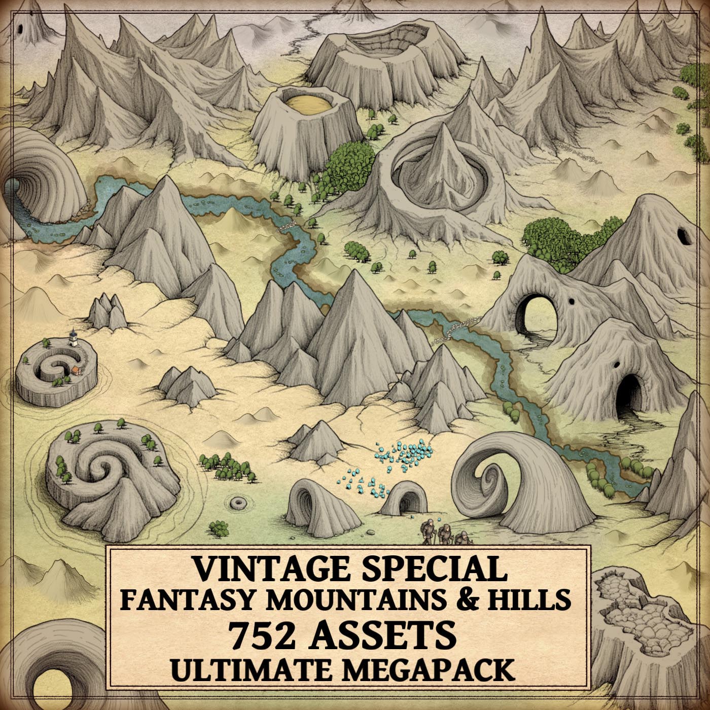
A deep exploration of terrain representation and the legacy revived by the Detailed Mountains & Hills – Old Cartography Assets Megapack

Mountains, hills, ridges, volcanoes, escarpments, and all the landforms included in the pack represent far more than decorative features. Across history, they formed a symbolic language that shaped geographical understanding, cultural identity, and storytelling. In both ancient traditions and modern fantasy map making, mountain drawings remain fundamental to how worlds, real or imaginary, are described.

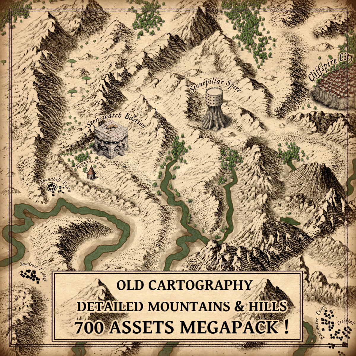
The Detailed Mountains and Hills – Old Cartography Assets MEGAPACK faithfully revives antique engraving styles with carefully crafted landforms such as mountains, mountain ranges, hill formations, broken ranges, buttes, plateaus, craters, knolls or escarpments. These drawings recall centuries of handcrafted maps and bring their evocative aesthetic into digital worldbuilding.

BUY AND DOWNLOAD The Detailed Mountains and Hills – Old Cartography Assets MEGAPACK HERE :

1. Origins of Mountain Symbolism in Early Maps and Their Legacy in Fantasy Map Icons

The representation of mountains began long before the notion of modern topography existed. Ancient cartographers understood that terrain could not simply be sketched scientifically, they needed symbolic forms.

Antiquity

  • Ptolemy’s Geographia (2nd century CE) included simple hill-shaped symbols that defined early Western cartographic convention.
  • In East Asian maps, especially during the Han and Tang dynasties, mountains symbolized cosmic balance and were drawn in isometric, stacked forms.

Medieval Europe

  • The Hereford Mappa Mundi depicted mountains as dramatic clusters marking sacred regions, mythical realms, and uncharted territories.
  • Islamic cartographer al-Idrisi used mountains as climatic markers and boundaries between cultural zones.

The landforms included in the pack; from isolated peaks to crags, highlands, and ridges; mirror this historical variety, making them ideal as fantasy map icons that enrich worldbuilding with cultural weight and ancient symbolism.

2. Renaissance Cartographic Innovation and the Emergence of Engraved Wonderdraft Assets

With the Renaissance came a flourishing of geographical detail and artistic precision.

  • Ortelius’ Theatrum Orbis Terrarum (1570) introduced engraved mountain clusters with consistent shading and distinctive silhouettes.
  • The Blaeu family refined the art of hachuring, creating some of the most beautiful mountain engravings ever published.
  • Cassini’s cartographic work (18th century) brought proto-topographic systems that displayed altitude and slope through shading direction.

The mountains, hills, volcanoes, and landforms in the pack clearly follow these engraving traditions:
sharp hatching, coherent light direction, clean contours, and expressive silhouettes. As Wonderdraft assets, they allow mapmakers to reproduce Renaissance-level realism inside modern digital tools.

3. Cultural Symbolism and Narrative Weight of Mountains in Ancient Maps and Modern Cartography Assets

Across civilizations, mountains on maps expressed significance beyond terrain.

Mountains as Natural Borders

Historical maps often marked political or cultural divisions using mountain chains:

  • The Pyrenees between France and Spain
  • The Apennines shaping Italian regional identities
  • The Himalayas forming colossal boundaries in South and Central Asia

In fantasy worldbuilding, the same logic applies. The mountain ranges, escarpments, cliffs, fragmented highlands, and plateaus in the pack serve to define kingdoms, territories, and frontier zones.

Mountains as Myth and Mystery

Throughout history:

  • The Rhipaean Mountains of Greek lore
  • The Mountains of the Moon, believed to feed the Nile
  • Early depictions of Vesuvius as a gateway to the underworld

The presence of volcanoes, craters, broken ranges, and dramatic cliffs in the pack mirrors these mythic connotations, allowing creators to construct narrative-rich landscapes.

Mountains as Navigation

Travelers and explorers once relied on:

  • Buttes
  • Knolls
  • Coastal cliffs
  • Ridgelines

These features helped orient caravans, sailors, and pilgrims. Their equivalents appear in the pack, serving both functional map readability and aesthetic coherence within modern cartography assets.

4. Practical Uses of Terrain Symbols in Fantasy Map Making With Fantasy Map Icons

The antique style of the pack is not merely decorative, it offers structural clarity for map composition.

A. Building Geography Modularly

With elements such as:

  • Mountains + mountain ranges
  • Hills + hill formations
  • Highlands + fragmented highlands
  • Volcanoes + craters
  • Plateaus + escarpments

worldbuilders can assemble fully coherent continents and regions with remarkable natural flow.

B. Clarity at Multiple Scales

Classical engravers designed symbols to remain readable even in small atlases.
Similarly, the pack provides landforms that retain clarity in both continent-sized maps and close-up regional maps.

C. A Full Vocabulary of Landforms

Few collections offer such richness:

  • mountains
  • hills
  • knolls
  • crags
  • ridges
  • lowlands
  • broken ranges
  • cliffs
  • plateaus
  • craters

This gives worldbuilders control over geological storytelling.

D. Paintable and Customizable Designs

Following the tradition of hand-colored maps, the pack includes variants suitable for:

  • direct painting
  • digital recoloring
  • neutral monochrome engraving styles

These characteristics make the pack’s landforms perfect fantasy map icons for hybrid analog–digital creation.

5. The Artistic Craft Behind Antique-Style Wonderdraft Assets

The drawings in the pack reflect meticulous craftsmanship:

Engraving-inspired hatching

Line density and direction mimic copperplate techniques of the 16th–18th centuries.

Shading Consistency

Most peaks and hills employ a unified light direction, recalling classic European atlas design.

Natural Composition

Mountain ranges, broken ranges, and ridges cluster organically, just as in historic works by Ortelius, Blaeu, and Sanson.

Historical Geological Realism

  • Volcanic shapes evoke early depictions of Etna and Vesuvius
  • Crater symbols recall lunar cartography
  • Highlands resemble Swiss shaded-relief engravings

The result is a set of Wonderdraft assets that are both historically inspired and artistically robust.

6. The Modern Revival of Antique Mapping Through Digital Cartography Assets

Why does this antique mountain style remain the gold standard in fantasy worlds?

Authenticity and Immersion

These landforms instantly communicate history, age, and believability.

Narrative Depth

A towering range hints at epic quests.
A smoking volcano signals danger and myth.
A fragmented highland suggests ancient cataclysms.

Aesthetic Harmony

The engraved look pairs perfectly with parchment textures and serif fantasy typography.

The mountains, hills, seas of ridges, buttes, and broken ranges of the pack help creators revive centuries-old mapmaking tradition in a modern context.

Direct Connection With Historical Art

This is the same style used (and loved) by Tolkien, whose maps were heavily influenced by 16th-century engraving conventions.

Thus, the MEGAPACK stands at the crossroads of history and creativity, offering digital cartography assets that feel timeless.

Conclusion: A Timeless Artistic Language Reborn Through Fantasy Map Icons

The Detailed Mountains and Hills – Old Cartography Assets MEGAPACK is more than an asset collection, it is a revival of the classical cartographic language that shaped humanity’s understanding of the world.

From ancient Greek scholars to medieval cosmographers, Renaissance engravers, Enlightenment explorers, and modern fantasy storytellers, mountains have always been symbols of mystery, power, ambition, and identity.

With its mountains, hills, volcanoes, plateaus, craters, cliffs, ridges, lowlands, knolls, and countless other landforms, the pack enables modern creators to tap into this heritage and build worlds that feel alive, authentic, and beautifully crafted.

In fantasy cartography, a mountain is never just a shape on a page.
It is story, culture, geology, myth, and art, all expressed through ink.

Posted on

Timeless Cartography Assets: The Role of Top-Down Towns, Castles, and Cities

top-down assets, Vintage cartography assets, fantasy map icons, towns, cities, buildings, Wonderdraft, Inkarnate

Maps have always been more than navigation tools. They are storytelling devices, cultural artifacts, and works of art. One of the most fascinating features of both historical and fantasy cartography is the use of top-down representations—miniature towns, villages, castles, piers, temples, and city walls that condense culture and history into symbols.

With modern Wonderdraft assets such as the Top-down towns, castles, villages, & more pack, today’s creators can continue this tradition, bringing life and depth to their fantasy maps while echoing centuries of cartographic practice.

BUY AND DOWNLOAD The Old Cartography top-down towns, castles, villages, & more  Assets Megapack here :

Grid-Planned Towns and Organic Settlements: Classic Fantasy Map Icons

Cartography has always revealed the contrast between organic towns and grid-planned cities.

  • Organic settlements, especially in medieval Europe, grew around castles, rivers, and trade roads. Their winding streets and irregular clusters reflected centuries of adaptation to local geography.
  • Grid-planned cities, by contrast, symbolize order and authority. While rooted in Roman military layouts, this approach became especially prominent in the 18th and 19th centuries in the United States. Cities such as Philadelphia and many Midwestern towns followed strict rectilinear grids, embodying Enlightenment ideals and practical governance.

This duality—wild frontier villages versus orderly planned colonies—remains central in fantasy storytelling. With the right fantasy map icons, you can bring this same historical authenticity into your own worlds.


Cartography Assets in the 18th and 19th Centuries

The Enlightenment and Industrial Age reshaped cartography. In the 18th and 19th centuries, maps were not only decorative—they became precise instruments of power, trade, and expansion.

  • Military maps showed bastioned forts, walls, and ramparts, emphasizing defense.
  • Colonial maps marked gridded towns to project administrative control.
  • Commercial atlases depicted piers, harbors, and watermills, highlighting networks of commerce.

These standardized cartography assets made it possible to instantly read a landscape: every castle spoke of power, every bridge of trade, every temple of belief.


Functional and Symbolic Roles of Fantasy Map Icons

What makes top-down symbols so enduring is their dual function: they are both practical and symbolic.

  • Bridges show strategic crossings and economic lifelines.
  • Temples and churches act as cultural and spiritual centers.
  • Castles and forts embody strength, protection, and political dominance.
  • Mines, watermills, and piers reveal resources, labor, and prosperity.

Just as 19th-century engineers used icons to control colonial territories, today’s worldbuilders use fantasy map icons to create depth, history, and narrative.


Wonderdraft Assets: Timeless and Decorative

From Enlightenment atlases to digital fantasy maps, top-down cartography has proven timeless. These representations are not bound to a single period—they evolve with culture and remain relevant today.

Their beauty lies in versatility: they orient the reader, provide context, and embellish a map with life. A well-placed fortress or walled city transforms a flat map into a living world.

The Top-down towns, castles, villages, & more collection of Wonderdraft assets allows modern creators to combine utility and artistry. These tools produce maps that are not only functional but visually captivating.


Fictional Resonances: From Fantasy Maps to Storytelling

Modern fantasy inherits these traditions:

  • Tolkien’s Minas Tirith, rising as a fortified emblem.
  • Martin’s Winterfell and King’s Landing, echoing medieval strongholds.
  • Countless tabletop RPG maps, where towns, villages, and forts serve both immersion and gameplay.

These examples prove that symbolic cartography is not just history—it is a living art form.


Conclusion: Cartography Assets for Worldbuilders

From grid-planned American cities to medieval strongholds, from Enlightenment atlases to modern fantasy campaigns, top-down cartography remains a universal language. Each bridge, rampart, or temple encodes both utility and meaning.

The Top-down towns, castles, villages, & more pack of fantasy map icons is more than a toolkit—it is a continuation of centuries of symbolic cartography. By using these cartography assets, you bridge history and imagination, building maps that are useful, decorative, and deeply cultural.

Posted on

Mediterranean Cartography Assets: Fortified Cities, Ports, Villages, Vineyards, and Wonderdraft Assets for Fantasy Maps

Fantasy map icons, Wonderdraft assets, Mediterranean ports, towns, vineyard, vines, fishing villages, cartography assets

From medieval cartography assets in antique atlases to modern fantasy map icons used in roleplaying games, the Mediterranean world has always been represented through powerful imagery: walled cities on cliffs, busy harbors, Roman arenas, spiral towers, and vineyard-covered hills. These elements are not merely decorative—they are fantasy map symbols of culture, economy, and identity.

The Mediterranean Settlements, Ports, Cities, Villages, Vineyards, Buildings – Vintage Assets Megapack embraces this tradition. Designed as high-quality Wonderdraft assets, it provides mapmakers with an authentic visual language that echoes antique maps while serving modern fantasy cartography.

BUY AND DOWNLOAD The Mediterranean Settlements – Vintage Assets Megapack here :


Fortified Cities: Anchors of Power in Cartography Assets

Throughout history, fortified cities have been among the most prominent cartography assets. Medieval maps such as the Hereford Mappa Mundi (c. 1300) placed Jerusalem at the symbolic center, not for its geographic accuracy but for its cultural weight. Portolan charts of the Mediterranean also emphasized Genoa, Venice, and Constantinople as towering walled cities, dominating both sea and land.

In fantasy cartography, these fantasy map symbols instantly communicate strength, political intrigue, and cultural centrality. The Megapack’s fortified cities and towns, inspired by Tuscan citadels and Dalmatian fortresses, allow creators to anchor their maps with centers of history, trade, and storytelling.


Ports and Fishing Villages: Essential Fantasy Map Icons

Ports were the lifeblood of the Mediterranean. Ancient Roman itineraries recorded harbors meticulously, while Venetian cartographers exaggerated coastal cities to highlight maritime trade. Fishing villages—clusters of huts and small boats—appeared as humble yet vital symbols of subsistence.

The Megapack enriches maps with fantasy map icons of fishing villages, fortified ports, and fishing boats. These are indispensable cartography assets for campaigns set in worlds of piracy, commerce, and naval exploration. A single barque in a harbor can spark stories of smugglers, merchant guilds, or seaborne kingdoms.


Hilltop Villages and Mediterranean Settlements

The Mediterranean is famous for its hilltop villages, from the whitewashed towns of Andalusia to the fortified borghi of central Italy. Their elevation offered both protection and identity: villages as beacons above the land.

Historical cartographers like Piri Reis (16th century) often depicted settlements perched on stylized hills, emphasizing their dominance. The Megapack’s hilltop villages and hamlets bring this tradition to fantasy mapping, providing Wonderdraft assets that naturally blend geography with storytelling.


Roman Villas: Symbols of Aristocracy and Culture

Roman villas were more than luxurious estates—they were symbols of power, refinement, and connection to the land. Antique maps of Italy, as well as Renaissance engravings, often highlighted villas to showcase noble estates and agricultural wealth.

The Megapack includes elegant villa structures as fantasy map icons, evoking grandeur and continuity with the classical past. On fantasy maps, a villa may mark a patrician’s estate, a monastery, or the headquarters of a secret order. These cartography assets do not just place buildings—they evoke entire lifestyles.


Arenas and Hippodromes: Theaters of Spectacle

Among the most iconic monuments of the Mediterranean are the Roman arenas, amphitheaters, and hippodromes. Structures such as the Colosseum in Rome or the Hippodrome of Constantinople were more than entertainment venues: they were symbols of imperial authority, civic unity, and collective memory.

Antique maps and city views—such as Braun and Hogenberg’s Civitates Orbis Terrarum (1572)—often included these monumental arenas, placing them at the heart of their cities. They were not drawn to scale but to impress, to remind viewers of the spectacle and grandeur of urban life.

The Megapack brings these traditions into the fantasy realm with detailed Wonderdraft assets of amphitheaters and hippodromes. As fantasy map symbols, they suggest cultures of games, rituals, and political gatherings. A map marked with an arena is never neutral—it speaks of power, spectacle, and the stories of thousands who once gathered there.


Vineyards, Cypress Trees, and Stone Pines

Cultural landscapes were central to antique cartography. Cypress trees often symbolized sacred spaces, while stone pines, with their iconic umbrella canopies, became shorthand for the Mediterranean skyline. Vineyards, long associated with wealth and trade, were included in maps to highlight abundance and prosperity.

The Megapack’s inclusion of these elements allows cartographers to enrich their worlds with cultural depth. A vineyard marks agricultural wealth and trade routes. Cypress-lined avenues may signal cemeteries or temples. Stone pines add atmosphere, instantly evoking the sunlit coasts of Italy or Greece. These are more than decorative cartography assets—they are narrative markers of place and culture.


Arabic Villages: Mediterranean Crossroads

The Mediterranean was a crossroads of civilizations: Latin, Greek, Arab, Berber, and Jewish. Maps from the Islamic Golden Age, especially those of al-Idrisi (12th century), represented domed houses and cubic settlements that contrasted with European towns.

The Megapack reflects this with fantasy map icons of Arabic villages and towns. These cartography assets embody cultural diversity, encouraging fantasy creators to portray trade, migration, and cultural encounters. A domed village on a map is an invitation to explore stories of merchants, scholars, or desert pilgrims.


Minimalistic Crowds and Decorative Elements

Antique cartographers often populated maps with tiny figures: pilgrims, soldiers, merchants. These details animated maps, making them not just geographic but human. The Megapack’s minimalistic crowds follow this tradition, allowing mapmakers to breathe life into plazas, ports, and marketplaces with subtle fantasy map symbols.

Alongside spires, citadels, towers, and statues, these Wonderdraft assets transform maps into works of art, echoing the richness of antique cartography while serving modern worldbuilding.


Why These Fantasy Map Icons Matter

Maps have always been both functional and cultural. On one level, these cartography assets mark settlements, resources, and defenses. On another, they encode meaning: a fortified city signifies strength, an arena spectacle, a vineyard prosperity, a tower ambition.

In fantasy worlds, employing Wonderdraft assets like those in the Megapack places creators in the lineage of cartographers like Mercator or Piri Reis. Maps become more than guides—they become mirrors of civilizations and carriers of myth.


Conclusion: Antique Cartography Assets for Modern Fantasy Maps

The Mediterranean Settlements Megapack is more than a set of icons—it is a bridge between antique mapmaking and fantasy storytelling. With fortified cities, ports, fishing villages, Roman villas, arenas, hippodromes, vineyards, Arabic towns, and natural landscapes, it offers one of the most complete libraries of fantasy map icons and fantasy map symbols available.

For creators seeking high-quality Wonderdraft assets or historically inspired cartography assets, this collection ensures that every map is not only functional but a work of art, rich with history, culture, and narrative potential.

Posted on

Bizarre & Beautiful Mountains and Rolling Hills with Cartography Assets

Wonderdraft assets, rolling hills, fantasy mountains, peaks, vintage cartography assets, fantasy map icons

In the art of mapmaking, especially in fantasy cartography and antique mapping traditions, terrain features are far more than mere topographical markers. They are mythic symbols, narrative devices, and aesthetic focal points. The Vintage Special Fantasy Mountains & Rolling Hills Assets – Ultimate Megapack celebrates this rich tradition by offering a collection of PNG images and Wonderdraft assets that evoke the magic, mystery, and history of fantasy lands. From spiraling mountains that resemble the coils of time to jagged peaks, volcano-like craters, and cave-pierced cliffs, these fantasy map icons are rooted in a visual language that spans centuries.

BUY AND DOWNLOAD The Vintage Special Fantasy Mountains & Rolling Hills Assets – Ultimate Megapack here :


A Tradition Rooted in History and Myth

The fantastical terrain elements found in this asset pack are not a modern invention. Ancient and medieval maps, such as the Tabula Peutingeriana, a Roman road map, or the Hereford Mappa Mundi (circa 1300 AD), used symbolic and exaggerated representations to indicate not just geography but the presence of mythological beings, religious landmarks, and exotic dangers. Mountains were often shown as trilobed towers or spire-like stacks, while hills might be depicted as perfect domes or mysterious spiral forms.

In this tradition, topography was illustrative rather than scientific. It conveyed meaning: a spiral mountain might signify divine presence, time distortion, or magical influence. A cave in a cliff face might represent the entrance to the underworld or the domain of a dragon. These cartography assets in your megapack tap directly into that language.


The Aesthetic and Symbolic Power of Fantasy Terrain Icons

Spiraled Mountain Shapes

The surreal spirals seen in your collection—reminiscent of ammonites or whirlpools of stone—suggest temporal anomalies or places of magical power. These shapes are visual shorthand for the strange and sublime. Such designs echo the mysterious spiral motifs found in the Nazca Lines or Celtic art, now reinterpreted for fantasy worlds.

Mountains with Shadowy Caves

Cave-pierced cliffs call to mind Plato’s Allegory of the Cave or the mythic underworld entrances of Dante’s Inferno. They serve as thresholds between the known and unknown—perfect narrative cues for adventures and legends. These icons ground your fantasy map in mystery and peril.

Snail-Shell Rock Formations

Spiral rock forms are not just decorative; they hint at natural formations shaped by immense time or cosmic events. Similar shapes appear in the cosmic landscapes of Moebius’s sci-fi comics or the dreamlike terrains of Hayao Miyazaki’s Nausicaä of the Valley of the Wind. On your map, they draw the eye and spark the imagination.

Tall Peaks and Jagged Ridgelines

Classic yet powerful, these shapes signal grandeur, challenge, and impassibility. They are essential for natural borders, dramatic focal points, and elevation cues. The pack includes clustered peaks, jagged ridges, and isolated spires, offering a visual hierarchy perfect for directing a viewer’s gaze across your fantasy landscape.


Utility Meets Imagination: Why Stylized Terrain Matters

The Vintage Special Fantasy Mountains & Rolling Hills Assets aren’t just beautiful—they’re functional. In the hands of worldbuilders and gamemasters, these icons are tools of storytelling:

  • Route Planning: Use cobblestone paths and medieval hikers to create implied narratives of travel, danger, or pilgrimage.
  • Dungeon Entrances: Shadowed caves and crater-like formations suggest hidden lairs and lost civilizations.
  • Resource Placement: Crashed crystals or volcanic pits can symbolize rare magical resources or hazards.
  • Cultural Significance: Spiral hills and crater ridges can represent sacred sites, aligned with celestial events.

Just like ancient mappa mundi, your fantasy map becomes not just a chart of space, but a story about power, culture, and myth.


A Cartographer’s Dream: What’s in the Megapack?

This Wonderdraft assets and PNG images megapack includes 752 high-quality icons divided into multiple terrain types and visual styles. Here are some highlights:

  • Spiral rock formations
  • Volcanic craters and pits
  • Tunnel mountains and ringed hills
  • Natural arches and snail-shell hills
  • Cratered mesas and collapsed formations
  • Rolling hills and mound-shaped terrain
  • Custom color, sample color, normal, and outlined versions

Every asset is designed to blend seamlessly into a hand-drawn or vintage-style map. Whether you’re designing a D&D campaign world or a Tolkien-inspired realm, these icons enhance immersion and visual storytelling.


From Antique Maps to Modern Fantasy Worlds

The visual style of this asset pack pays homage to the woodcut illustrations of medieval Europe and Renaissance-era atlases. The detailed hatching and monochrome foundations evoke the tactile charm of maps drawn on parchment, while the colorized versions breathe new life into this heritage.

Fantasy worldbuilding is, at its core, the construction of believable illusions. With these terrain icons, your world will feel old, storied, and steeped in myth—even if it’s freshly imagined. Like the portolan charts of the 15th century or the myth-infused sketches of early explorers, your map becomes a bridge between imagination and cartographic art.


Conclusion: A New Chapter in Fantasy Cartography

The Vintage Special Fantasy Mountains & Rolling Hills Assets – Ultimate Megapack isn’t just a toolkit; it’s a visual language steeped in history, culture, and legend. It reconnects fantasy cartography with its ancient roots, blending the symbolic power of antique maps with the aesthetic demands of modern storytelling.

For worldbuilders, game masters, and visual storytellers, this pack is an essential trove of cartography assets. With 752 versatile and beautifully designed fantasy map icons, it invites you to chart realms not just with accuracy, but with wonder.

So the next time you place a spiral mountain on your map, remember: you’re not just marking a location—you’re evoking a legacy.

Posted on

Imperial & High Elf Fortified Cities: The Cultural and Architectural Legacy in Fantasy Cartography

Fantasy map assets, High elf city, high elf settlements, Wonderdraft icons, Wonderdraft assets, Imperial towns

Introduction: The Cultural Depth of Imperial & High Elf Cities in Wonderdraft Assets

Fantasy cartography is more than just map-making—it’s a cultural expression that defines civilizations through architecture, geography, and artistic representation. The Imperial & High Elf Fortified Cities, Towns, Settlements, and Structures – Vintage Assets Megapack brings these worlds to life with Wonderdraft assets that showcase the grandeur of imperial strongholds and the mystical elegance of High Elf cities. These fantasy map icons not only enhance visual storytelling but also reflect the historical inspirations and deep cultural symbolism behind these legendary cityscapes.

BUY AND DOWNLOAD The Imperial & High Elf Fortified Cities, Towns, Settlements, and Structures – Vintage Assets Megapack here :

Imperial Cities: Architecture of Power and Order

Imperial civilizations in fantasy settings often resemble the great empires of antiquity, particularly Rome, Byzantium, and the Holy Roman Empire. Their urban designs emphasize control, hierarchy, and resilience, much like their real-world inspirations.

Key Features of Imperial City Cartography

  • Walled Towns & Fortresses – Defensive structures reflecting the strategic planning of medieval strongholds.
  • Amphitheaters & Grand Palaces – Inspired by the Colosseum and Hagia Sophia, representing civic pride and imperial dominance.
  • Aqueducts & Engineering Marvels – Mirroring the Pont du Gard and Byzantine waterworks, showcasing advanced infrastructure.

In fantasy maps, imperial cities often appear as large, structured metropolises with straight roads, circular plazas, and well-defended perimeters, suggesting a civilization built on organization and military strength.

High Elf Cities: The Harmony of Magic and Architecture

Unlike the rigid order of imperial cities, High Elf settlements are fluid, mystical, and deeply connected to nature. They do not merely occupy the landscape; they become part of it. Their architecture reflects ethereal beauty, arcane power, and spiritual enlightenment, a style influenced by:

  • Mythological Avalon – The legendary, unreachable island of Celtic lore, hidden by mists and magic.
  • Tolkien’s Elven Realms – Rivendell and Lothlórien, built seamlessly into valleys and forests, symbolizing a balance between civilization and wilderness.
  • Ancient Persian & Indian Stepwell Cities – Multi-tiered, symmetrical structures descending into sacred waters, much like High Elf terraced cities in fantasy maps.

Key Elements of High Elf Cartography

1. Towering Spires and Floating Cities

  • Mastery over magic and gravity – Cities are shaped by arcane forces rather than stone and mortar.
  • Spiritual aspiration – Towers reach towards celestial realms, symbolizing enlightenment.
  • Seclusion and exclusivity – Hidden among clouds or enchanted forests, these cities are inaccessible to outsiders.

2. Tiered Cities & Noble Estates

  • Respect the land by adapting to natural elevations.
  • Create a sense of order, where noble estates sit above the common dwellings.
  • Reflect an ethereal hierarchy, where spiritual and arcane centers sit at the highest levels.

3. Viaducts, Spiral Paths & Water Elements

  • A blend of natural beauty and elven engineering.
  • The importance of ritualistic purification – flowing water as a spiritual conduit.
  • Connection between settlements, much like the real-world Grand Canal of China or Venetian waterways.

4. Temples and Arcane Sanctuaries

  • Preserve ancient knowledge, much like the Great Library of Alexandria.
  • Feature celestial motifs, glowing crystals, and open-air observatories.
  • Are designed to channel magical energies through sacred geometry and ley lines.

Unlike human empires, which focus on defensive strength, High Elf cities are designed to channel natural and arcane energies, making them resistant to decay, time, and conventional siege warfare.

Fantasy Cartography as a Cultural Expression

Maps in fantasy settings are not just practical tools; they are expressions of history, belief, and artistic tradition. The distinction between Imperial and High Elf cities is not merely aesthetic—it reflects two opposing cultural worldviews:

  • Imperial Cities symbolize control, expansion, and the mastery of land through engineering.
  • High Elf Cities represent spiritual enlightenment, harmony with nature, and the pursuit of magical wisdom.

The way these cities are represented in cartography assets influences how players, readers, and viewers interact with the world. An imperial stronghold suggests a place of order and law, while a High Elf metropolis hints at hidden wisdom and ancient secrets.

Conclusion: A Deeply Cultural Approach to Fantasy Map Assets

The Imperial & High Elf Fortified Cities, Towns, Settlements, and Structures – Vintage Assets Megapack is not just a collection of fantasy map icons—it is a tool for storytelling and cultural expression.

By studying the architectural and cartographic traditions of both Imperial and High Elf civilizations, worldbuilders can craft maps that are not only visually stunning but rich with depth and historical resonance.

Whether you are constructing a mighty empire with vast aqueducts or designing a mystical elf city floating among the clouds, these cartography assets offer an unparalleled level of detail and artistic authenticity.

Bring your fantasy world to life with maps that tell a story beyond geography—maps that reveal culture, myth, and the spirit of an age.

Posted on

The Role of Fantasy Map Icons in Antique and Fantasy Cartography Assets

Wonderdraft assets, fantasy map icons like king figure, medieval shops, vintage cartography assets

Exploring the Utility, Culture, and Aesthetic of Vintage Fantasy map icons.

Maps have always been more than simple tools for navigation; they are artistic expressions of power, knowledge, and imagination. From the richly detailed mappa mundi of the Middle Ages to the intricate fantasy map assets found in role-playing games and novels, cartographers have used symbols to make maps both visually appealing and functionally intuitive. These symbols serve to identify key landmarks, fortifications, magical sites, and economic centers, making maps an essential narrative device for both real-world explorers and fantasy world-builders.

The Fantasy Map Icons Ultimate Collection – POIs Vintage Assets Megapack is a carefully crafted set of Wonderdraft assets designed to capture the aesthetic of antique cartography while offering a broad selection of assets to enhance world-building. With its hand-drawn, vintage style, this collection fits seamlessly into historical and fantasy settings alike.

BUY AND DOWNLOAD The Fantasy Map Icons Ultimate Collection – POIs Vintage assets Megapack here :

Heraldry, Nobility & Leadership in Fantasy Map Icons

Throughout history, the depiction of power and authority has been central to cartography. Medieval maps often marked the dominions of noble families with heraldic symbols, crowns, and fortress icons to represent castles and fiefdoms. This visual shorthand conveyed ownership and influence, much like a coat of arms identified knights on the battlefield. In fantasy map assets, these same principles apply. A kingdom’s capital can be marked with an elaborate crown, while the stronghold of a warlord might be represented by crossed swords or a sigil-bearing shield.

Wonderdraft assets like heraldic shields and noble busts serve to emphasize political territories, defining the borders between rival factions or ancient dynasties. These cartography assets are particularly effective in tabletop RPGs or fantasy novels where world-building is crucial. A player glancing at a map should immediately recognize which areas are under noble rule, where alliances might shift, or where ancient bloodlines still hold sway over the land.

Settlements, Fortresses & Infrastructure in Cartography Assets

One of the most practical uses of fantasy map icons is in marking settlements, from humble villages to grand cities. Antique maps often represented cities with small clusters of buildings or even stylized towers, a convention that remains popular in fantasy cartography assets. The size and complexity of these symbols can indicate a settlement’s importance—while a simple hut might represent an isolated farming community, a grand walled city icon might signify a thriving metropolis or a kingdom’s capital.

Castles and fortresses are equally important in Wonderdraft assets, as they represent military strongholds, centers of power, or ancient bastions of civilization. On many medieval maps, castles were exaggerated in size to reflect their political and strategic significance rather than their actual geographic footprint. This tradition carries over into fantasy map assets, where a fortress icon can indicate a keep teeming with knights, an ancient ruin occupied by bandits, or a cursed citadel shrouded in mystery.

Bridges, roads, and ports also play a vital role in cartography assets. Docks, bridges, and trade routes can transform a static map into a dynamic world where commerce, war, and migration shape the land. A well-placed harbor icon suggests bustling maritime trade, while a marked road hints at caravan routes or dangerous passes where bandits lurk. These fantasy map assets help create a sense of movement and connection between locations, making the world feel alive.

Arcane & Mystical Symbols in Fantasy Map Assets

Fantasy settings thrive on the supernatural, and fantasy map icons play a crucial role in defining the presence of magic, ancient secrets, and arcane forces. Throughout history, maps have featured mythical symbols to represent the unknown—whether it was the sea monsters populating Renaissance maps or the labyrinthine temples of lost civilizations. In a fantasy world, these mystical markers serve as narrative signposts, guiding adventurers to places of wonder and danger.

Pentagrams and occult circles can indicate sites of forbidden knowledge, where ancient sorcerers performed dark rituals or where reality itself bends to eldritch forces. Mystic masks and skull motifs hint at haunted lands, cursed temples, or places where spirits linger. These symbols are especially useful in cartography assets, as they immediately set a location apart as mystical, secretive, or perilous. Whether designing a map for a tabletop RPG or a novel, adding these elements can signal areas of high magic or deep lore without the need for lengthy explanations.

Alchemy and potion bottles are also key elements in many Wonderdraft assets, representing magical academies, enchanters’ shops, or legendary elixirs hidden in forgotten ruins. These symbols not only reinforce the presence of magic but also add a level of world-building depth—does this land value alchemy as a science, or is it feared as heresy? By placing arcane fantasy map icons strategically, a creator can imply entire cultural narratives about how magic is perceived and utilized within the world.

Economy, Trade & Wealth in Wonderdraft Assets

Maps have long been instruments of commerce, marking trade routes, markets, and centers of wealth. In historical cartography, cities known for their riches were often depicted with gold coins, merchant seals, or ornate architectural designs. The Catalan Atlas (1375) famously portrayed the King of Mali holding a golden nugget, emphasizing the region’s wealth and its significance in the gold trade.

In fantasy map assets, gold coins and treasure bags can indicate prosperous trade hubs, legendary hoards, or secret caches of ancient wealth. A well-placed chest icon might suggest a hidden pirate treasure, while stacked coins could signify a thriving economic capital. Dice and playing cards, meanwhile, hint at gambling dens, rogue hideouts, or places where fortune favors the bold. These fantasy map icons provide both practical information and storytelling depth, reinforcing the idea that economic power is as crucial as military might in shaping a world.

Beyond simple wealth, gears and mechanical symbols can represent industrial advancements, clockwork cities, or even steampunk-inspired civilizations. Including such Wonderdraft assets can distinguish technologically advanced regions from more traditional medieval settings, offering visual cues about cultural and technological disparities within the world.

Warfare & Conflict Zones in Fantasy Map Icons

Conflict has shaped both real and fictional landscapes, and maps have long used symbols to represent battlefields, sieges, and fortifications. Crossed swords, banners, and siege equipment indicate areas of past or ongoing warfare, while prison bars and gallows mark places of justice—or oppression. These elements are essential in world-building, as they visually communicate the tensions and dangers present in a land.

A map dotted with fortress icons suggests a heavily militarized region, while a battlefield marker might tell the story of a historic war that still impacts the present. These Wonderdraft assets are especially useful in role-playing settings, where knowing the locations of major conflicts can influence character backstories, political intrigue, and campaign settings.

Conclusion: The Power of Wonderdraft Assets and Fantasy Map Icons in World-Building

The Fantasy Map Icons Ultimate Collection – POIs Vintage Assets Megapack is an invaluable tool for storytellers, game designers, and cartographers looking to create immersive worlds. Whether designing a tabletop RPG map, a fantasy novel setting, or a detailed strategy game world, these fantasy map assets provide the perfect blend of historical inspiration and imaginative storytelling.

By integrating assets that reflect heraldry, settlements, arcane sites, trade hubs, and war zones, a creator can breathe life into their maps, making them not just guides, but gateways into unforgettable adventures.

Posted on

Wonderdraft Assets for War Maps: Military Symbols in History, Strategy & Fantasy Cartography

WW2 map symbols, Wonderdraft assets, arrows, barracks, military base, units, tanks, planes, ships, modern war

Introduction: The Power of Symbols in War and Maps

Maps have always been more than just geographical representations—they are strategic tools, historical records, and storytelling devices. Whether in WW2 military maps, wargaming strategy charts, or fantasy maps, military symbols play a crucial role in depicting movements, tactics, and battles.

The WW2 & Modern War Symbols & Icons – Old Cartography Assets Megapack faithfully recreates these historical and strategic map symbols, offering a versatile set of military markers perfect for Wonderdraft assets users, wargamers, and fantasy worldbuilders.

But why are these symbols so effective, and what is their significance in both real-world strategy and fictional cartography?

This article explores the history, function, and artistic impact of military map symbols, tracing their evolution from WW2 battle plans to their influence on board games, wargaming, and fantasy cartography assets.

BUY AND DOWNLOAD The WW2 & Modern War Symbols & Icons – Old Cartography Assets Megapack here :


I. The Historical Role of Military Symbols in War Maps

1. The Birth of Military Cartography

The use of symbols in military maps dates back to antiquity. Generals such as Hannibal, Julius Caesar, and Sun Tzu relied on hand-drawn battlefield sketches to coordinate their forces. However, it was only in modern warfare that a standardized system of military icons was developed to improve strategic communication.

During World War II, the need for accurate, universally understood battle maps became crucial. Both Allied and Axis forces used cartography assets to illustrate:

  • Airfields, naval bases, and headquarters
  • Armored divisions, infantry battalions, and artillery positions
  • Supply depots, fortifications, and defensive lines
  • Naval fleets, aircraft carriers, and submarines

By reducing complex information into simple, recognizable symbols, military planners could quickly assess battle scenarios, strategize offensives, and organize defenses. These same principles are now used in Fantasy map icons for tabletop RPGs and wargaming.


2. Famous Examples of WW2 Strategic Maps

Some of the most influential WW2 military maps showcase how symbols and cartography assets were essential to strategic planning.

D-Day Invasion Maps (1944)

The Normandy landings required meticulous planning, with maps detailing:

  • Paratrooper drop zones
  • Naval bombardment targets
  • Tank and infantry movement routes

Eastern Front Operational Maps (1941-1945)

Used by German and Soviet forces, these maps depicted:

  • Frontline shifts and encirclements
  • Supply routes and logistics hubs
  • Defensive positions and fortifications

Pacific War Naval Strategy Maps

Both the U.S. Navy and the Imperial Japanese Navy used maps to track:

  • Aircraft carrier movements and battle group formations
  • Island invasions and amphibious landings
  • Submarine patrol zones and naval blockades

These real-world examples highlight why military symbols matter—they allow complex operations to be communicated clearly, a principle still applied in Fantasy map icons and Wonderdraft assets today.


II. Military Symbols in Wargaming and Fantasy Cartography

1. From WW2 Maps to Wargames and Strategy Games

The effectiveness of military symbols didn’t end with real-world wars. After WW2, wargaming and strategy games adopted WW2-inspired cartography assets to simulate battles, train officers, and entertain enthusiasts.

Examples of Wargames Using Military Symbols:

  • Axis & Allies (1981-present) – A strategic board game featuring armies, fleets, and aircraft represented by classic WW2-style icons.
  • Hearts of Iron (2002-present) – A grand strategy video game using WW2-style cartography assets to command divisions, naval units, and air squadrons.
  • Squad Leader (1977) – A tactical war board game that relies on WW2 military symbols for clarity in combat scenarios.

These symbols became universal in wargaming, shaping how players interact with battle maps.


2. The Role of Military Symbols in Fantasy and Fictional Maps

Even in fantasy worlds, war maps borrow from historical military cartography assets. Many fictional settings use Fantasy map icons similar to real-world war symbols to represent battles, invasions, and defenses.

Fictional War Maps Inspired by Military Cartography:

  • The War of the Ring (Lord of the Rings) – Maps of Middle-earth battles include army movements, siege locations, and fortifications reminiscent of WW2-style strategic maps.
  • Game of Thrones Battle Maps – These maps use movement arrows, fortress markers, and military banners, similar to historical war maps.
  • The Horus Heresy Campaign Maps (Warhammer 40k) – Galactic war maps in Warhammer 40K showcase fleet deployments, planetary invasions, and battlefronts, much like WW2 military maps.

This demonstrates how WW2-style symbols and cartography assets remain relevant—even in fantasy and futuristic settings.


III. The Utility and Aesthetic of War Map Symbols

1. Why Use Military Symbols in Maps?

The WW2 & Modern War Symbols & Icons Megapack offers more than just Wonderdraft assets for map creators—it serves both functional and aesthetic purposes in cartography. These symbols provide:

Tactical Clarity

  • Clearly define troop positions, air bases, and supply routes.
  • Show advancing and retreating forces with movement arrows.
  • Highlight key conflict zones and strategic fortifications.

Historical and Cultural Authenticity

  • Perfect for WW2 reenactments, historical RPG campaigns, and alternate history settings.
  • Adds a realistic war aesthetic to maps in fantasy, steampunk, or cyberpunk worlds.
  • Faithfully replicates old military cartography assets from WW2 and beyond.

Decorative and Immersive Value

  • Evokes the look of antique war maps, enhancing the vintage, old-cartography style.
  • Makes historical, tactical, and fantasy maps more engaging and visually striking.

Conclusion: The Lasting Impact of Military Cartography

Military symbols are not just about strategy—they are visual storytelling tools that bridge history, gaming, and fantasy. Whether used in WW2 operations, wargaming scenarios, or fantasy battle maps, these symbols simplify complex information while enhancing immersion.

The WW2 & Modern War Symbols & Icons Megapack captures this timeless cartographic tradition, making it an essential addition for Wonderdraft assets collectors, worldbuilders, and wargaming enthusiasts.

By using historically inspired war symbols, you’re not just designing a map—you’re creating a battlefield, a strategy, and a story.