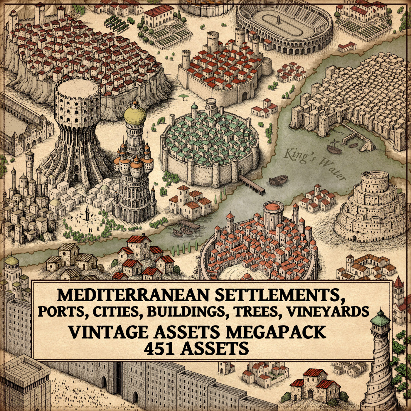
Posted on Leave a comment

Mazes and Fantasy Map Symbols in Cartographic Art

wonderdraft resources, cartography assets and symbols, hedge maze and labyrinth assets pack

In the vast realm of fantasy and ancient cartography, mazes and labyrinths have played a captivating role, transcending mere navigational tools to become symbols of mystery, challenge, and intricate design. The Mazes & Labyrinths Vintage Assets Megapack promises to bring these captivating elements to life in the realm of fantasy mapping, drawing inspiration from the rich history of real-world maps and fictional landscapes.

BUY AND DOWNLOAD The Mazes & Labyrinths Vintage Assets Megapack :

I. The Historical Tapestry of Mazes and Labyrinths

A. Ancient Maps:

Ancient civilizations, such as the Greeks, Romans, and Egyptians, often incorporated mazes and labyrinths into their cartographic representations. One notable example is the Cretan Labyrinth, a mythical construct associated with the Minotaur. The symbolism of these structures extended beyond mere physical spaces, representing spiritual journeys and the complexities of life.

B. Hedge Mazes and Garden Mazes:

Hedge mazes, prevalent in European gardens since the Renaissance, found their way into both real and imaginary landscapes. The Mazes & Labyrinths Vintage Assets Megapack draws inspiration from the intricate patterns of historical garden mazes, reflecting the elegance and sophistication of bygone eras.

C. Stone Mazes and Ruins Mazes:

The fascination with stone mazes and ruins in maps can be traced to medieval and Renaissance periods. Real-world examples, such as the Chartres Cathedral labyrinth in France, showcased intricate stone designs that served both spiritual and functional purposes. The megapack captures this essence, offering a diverse range of stone mazes and ruins that add a touch of antiquity to fantasy maps.

II. The Megapack: A Glimpse into Fantasy Cartography

The Mazes & Labyrinths Vintage Assets Megapack boasts an array of elements designed to evoke the charm of antique maps. From town mazes and city mazes to rocky mazes and mage’s mazes, the pack seamlessly blends fantasy elements with historical aesthetics, offering cartographers a treasure trove of assets to create immersive and visually stunning maps.

A. Decorative Trees and Monoliths:

Beyond mazes, the megapack includes decorative trees and monoliths, enhancing the overall atmosphere of fantasy maps. These elements not only serve as visual embellishments but also reflect the diverse landscapes found in both historical and fantastical settings.

B. Cultural Significance:

Mazes and labyrinths have long held cultural significance, representing challenges, quests, and the journey of self-discovery. The megapack allows creators to infuse these cultural elements into their fantasy worlds, providing a canvas for storytelling and exploration.

C. Utilitarian and Decorative Aspects:

In both historical and fantasy maps, mazes served utilitarian purposes, guiding travelers or symbolizing a sacred journey. The megapack acknowledges this dual role, offering assets that blend functionality with the ornate, creating maps that are both practical and visually appealing.

Conclusion

The Mazes & Labyrinths Vintage Assets Megapack breathes life into fantasy cartography, drawing inspiration from the rich history of mazes and labyrinths in both real-world maps and imaginative tales. By seamlessly blending utility, cultural symbolism, and decorative elements, this megapack invites creators to embark on a journey through time and fantasy, where every twist and turn tells a story of mystery and adventure.

Posted on Leave a comment

Cartography assets : The Universal Language of Silhouette Landmarks & Points of Interest

wonderdraft assets, fantasy map symbols, point of interest markers, cartography assets

In the realm of fantasy and antique maps, the portrayal of towns, villages, castles, and a myriad of other landmarks in the form of intricate silhouettes has captivated cartographers and map enthusiasts alike. The marriage of functionality and artistry, inspired by both historical cartography and fantastical imaginings, finds a stunning embodiment in the Vintage Point of Interest Markers – Mega Landmarks Collection Pack.

BUY AND DOWNLOAD The Vintage Point of Interest Markers – Mega Landmarks Collection Pack :

Silhouettes in Historical Cartography: A Journey into the Past
The use of silhouettes to represent landmarks in maps is deeply rooted in the traditions of ancient cartography. Examining historical maps reveals a predilection for simplicity in conveying information, and silhouettes emerged as a powerful tool to achieve this. Early maps often featured silhouette-like representations of towns, castles, and natural features, providing a clear and concise overview for navigators and explorers.

One noteworthy example is the famed 16th-century map by Sebastian Münster, where towns and villages are elegantly depicted as distinct silhouettes against the landscape. This aesthetic choice not only facilitated navigation but also added an artistic flair to the maps of the time.

Fantasy Maps and Silhouette Elegance
Fast forward to the world of fantasy maps, and we witness a seamless integration of historical cartographic practices with imaginative elements. The Vintage Point of Interest Markers pack effortlessly captures the essence of old-world maps by presenting fantasy landmarks as captivating silhouettes. The collection includes everything from quaint villages and imposing castles to mythical creatures like dragons and sea serpents, all rendered in a classic black silhouette style reminiscent of antique cartography.

Utility and Culture: The Dual Role of Silhouette Landmarks
The utility of using silhouettes for point-of-interest markers extends beyond mere aesthetics. Silhouettes, with their simplicity and clarity, serve a practical purpose in aiding navigation and comprehension, particularly in densely packed maps. Whether for adventurers in a fantasy world or explorers of uncharted territories, the immediate recognition of landmarks is crucial, and silhouettes excel in this regard.

Culturally, the use of silhouettes in maps echoes a sense of tradition and nostalgia. It harks back to a time when cartography was as much an art form as it was a scientific endeavor. By emulating the visual language of antique maps, the Vintage Point of Interest Markers Megapack not only serves a functional purpose but also taps into a collective cultural memory, resonating with enthusiasts who appreciate the heritage of mapmaking.

Decorative Elements and Artistic Expression
Beyond their practical applications, silhouette landmarks contribute significantly to the aesthetic appeal of maps. The intricate detailing and artistic rendering of each silhouette in the collection transform maps into visual masterpieces. Whether adorning the walls of a fantasy novel enthusiast or serving as a key visual element in a tabletop role-playing game, these silhouettes enhance the overall visual experience and storytelling aspect of the maps.

Real and Fictional Inspirations: A Blend of Fact and Fantasy
To understand the roots of silhouette representations, one can look to historical maps such as the aforementioned works of Sebastian Münster or the iconic medieval Mappa Mundi. In fiction, maps from classic literature, like J.R.R. Tolkien‘s Middle-earth maps, continue this tradition. Tolkien’s maps, in particular, showcase the strategic use of silhouettes to highlight key locations in his fantastical world.

The Vintage Point of Interest Markers pack seamlessly weaves together these historical and fictional inspirations, creating a bridge between the tangible past and the boundless realms of imagination.

In Conclusion
The Vintage Point of Interest Markers – Mega Landmarks Collection Pack stands as a testament to the enduring legacy of silhouette representations in maps. From the practical advantages of aiding navigation to the cultural resonance of evoking historical cartographic traditions, these silhouettes encapsulate a rich tapestry of functionality, culture, and artistry. As maps continue to guide us through both real and imagined worlds, the timeless elegance of silhouettes ensures their place as indispensable elements in the cartographer’s toolkit.

Posted on Leave a comment

Chilled Chronicles: Navigating Snowy Realms with Cartography Assets

wonderdraft assets, winter, snowy structures, christmas, footprints, cartography assets, map symbols

Journeying through the frozen landscapes depicted in antique maps and fantastical realms reveals a captivating tapestry of winter cartography. Beyond the allure of the Winter & Snow Complete Megapack – Vintage Assets Pack, this article seeks to unravel the historical and imaginative layers behind representations of snow-covered cities, ice castles, ancient ruins beneath the snow, and a myriad of other wintry elements.

BUY AND DOWNLOAD The Winter & Snow Complete Megapack – Vintage Assets Pack :

Snowy Cities and Frozen Abodes:

Snow-covered cities and hamlets have a storied history in cartography. The quaint charm of these settlements, blanketed in white, is reminiscent of ancient villages adapting to winter’s harsh embrace. Within the Winter & Snow Complete Megapack, the inclusion of snowy hamlets and villages preserves this aesthetic, transporting map enthusiasts to a world where the cold weaves its tales through the architecture of the past.

Ice Castles and Dungeons:

The megapack introduces the enigmatic allure of ice castles and fortresses, echoing both historical marvels and fantastical realms. Drawing inspiration from medieval structures and mythical tales, these frozen citadels stand as testaments to the power and mystery entwined in winter landscapes. Ice dungeons, with their chilling depths and hidden secrets, add layers of complexity, beckoning adventurers into subterranean realms of ice and intrigue.

Ruins Under Snow and Ancient Mysteries:

Beneath the pristine layers of snow lie the remnants of lost civilizations, beautifully represented in the megapack’s snowy ruins and remains. This concept draws from the real-world archaeological fascination with uncovering the mysteries of ancient cultures. The maps guide explorers through a landscape where echoes of the past linger, inviting contemplation of the stories etched into the frozen terrain.

Igloos and Arctic Dwellings:

Dotted across the wintry expanse are igloos and arctic towns, showcasing the adaptability of cultures to icy environments. The megapack captures the essence of these dwellings, providing a glimpse into the lives of those who thrive in the harshest of winter conditions. This inclusion not only adds realism but also serves as a nod to the diversity of winter landscapes across the globe.

Winter World Trees and Festive Decor:

World trees, depicting towering sapins or Christmas trees, evoke both a sense of wonder and cultural significance. In the megapack, these trees become focal points, representing not only geographical markers but also symbols of celebration. The addition of candy canes planted in the snow reinforces the festive atmosphere, blending mythology with a touch of holiday cheer.

Mythical Beings and Legends:

Winter maps wouldn’t be complete without the inclusion of legendary creatures like the yeti, bigfoot, and frost ogres. The megapack breathes life into these mythical beings, creating encounters that transcend mere navigation. Tracks in the snow add an element of realism, leaving adventurers to ponder the presence of these elusive entities in the frozen landscapes.

Crystal Formations and Enchanting Elements:

One of the standout features of the megapack is the meticulous representation of crystal formations embedded in the ground. These geological marvels not only add visual appeal but also introduce an enchanting aspect to the wintry landscapes. The sparkling crystals, with their varied shapes and sizes, contribute to the otherworldly ambiance of the maps.

Conclusion: Navigating the Uncharted Winter Realms

The Winter & Snow Complete Megapack – Vintage Assets Pack emerges as a treasure trove of winter cartography, seamlessly blending historical influences with fantastical elements. As we navigate the frozen landscapes, we find ourselves immersed in a world where the past, present, and mythical coalesce, creating maps that tell stories beyond navigation—stories of civilizations lost in the snow, of mythical creatures roaming icy expanses, and of the enchanting beauty of crystal-laden terrains. This megapack is not just a collection of assets but a gateway to exploring the uncharted realms of winter wonder.

Posted on Leave a comment

Journey Through Fantasy Cartography : Dungeons and Pointing Hands on Maps

wonderdraft assets, dungeons, ritual circles, magic circles, evil pointing hands, cartography assets

Embark on a journey through the annals of history and fiction as we unravel the captivating role of dungeons, pointing hands, and magic circles in the intricate world of maps. The Ultimate Dungeons Megapack – Vintage Assets Pack serves as our guide, offering an immersive collection that draws inspiration from both tangible history and fantastical realms. Let’s delve deeper into the historical context and fictional allure of these elements.

BUY AND DOWNLOAD The Ultimate Dungeons Megapack – Vintage Assets Pack :

Dungeons: Echoes of Ancient Strongholds
The concept of dungeons traces its roots to medieval history, where fortified castles and sprawling catacombs housed prisoners, treasures, and mysteries. The Ultimate Dungeons Megapack brings this history to life with assets like the Brooding Bastion, reminiscent of the imposing dungeons depicted in historical manuscripts. Think of the Bastille during the French Revolution or the Tower of London, and you’ll grasp the significance of dungeons as symbols of power, intrigue, and peril.

Pointing Hands: Navigational Wisdom in Historical Maps
Historical maps often featured pointing hands, directing explorers toward uncharted territories and potential hazards. One such example can be found in ancient maritime maps, where illustrations of disembodied hands guided sailors through treacherous waters. The Ultimate Dungeons Megapack pays homage to this tradition with evil pointing hands, mirroring the ominous warnings found on maps that marked territories plagued by mythic beasts, pirates, or other perilous encounters.

Magic Circles: Arcane Secrets Across Time
Magic circles, laden with esoteric symbols and arcane knowledge, have left an indelible mark on history and fiction alike. Consider the intricate circles etched into grimoires of medieval sorcery or the summoning circles depicted in Renaissance-era occult manuscripts. The Ultimate Dungeons Megapack – Vintage Assets Pack incorporates this historical mystique, providing map creators with circles that evoke the ancient rituals practiced by alchemists, sorcerers, and secret societies.

Dungeon Keepers: Guardians of Forbidden Knowledge
Throughout history and fiction, mysterious guardians have stood watch over hidden realms. The dungeon keepers in the Ultimate Dungeons Megapack find their inspiration in the hooded sentinels of Gothic literature and ancient manuscripts. Picture the guardians of forbidden knowledge in Umberto Eco’s “The Name of the Rose” or the enigmatic figures protecting ancient tombs in Edgar Allan Poe’s tales – these hooded keepers add layers of intrigue and danger to the maps they inhabit.

Conclusion:

In the symphony of historical echoes and fictional wonders, the Ultimate Dungeons Megapack – Vintage Assets Pack emerges as a tapestry woven with threads from both realms. From the echoes of medieval dungeons and maritime exploration to the arcane symbols of magic circles and the guardians inspired by literature, this collection invites map creators to craft narratives that transcend time. As we traverse the realms of history and fiction, let the dungeons, pointing hands, and magic circles guide us through a landscape where every detail tells a story and adventure awaits at every turn.

Posted on Leave a comment

Antiquity Maps Reimagined: Cartography Assets of the Roman Empire & Ancient Greece

wonderdraft assets, Roman Empire and Ancient Greece towns, settlements, arenas, temples, sanctuaries, fantasy map assets

I have always marveled at the representations of cities, arenas, settlements, and architectural styles inspired by the Roman Empire and ancient Greece. These elements play a pivotal role in shaping the worlds of fantasy maps. In this article, we’ll explore the historical and mystical aspects that influence the creation of fantasy maps, giving special attention to the architecture of the Roman and Greek ancient worlds.

BUY AND DOWNLOAD The Roman Empire & Ancient Greece Settlements and Towns – Vintage Assets Pack :

Architectural Styles of the Roman Empire and Ancient Greece

The architectural grandeur of the Roman Empire and the classical elegance of ancient Greece have left an indelible mark on the world of fantasy cartography. In these fantastical realms, cities sometimes mirror the grand cities of antiquity, and temples replicate the intricate designs of Roman and Greek places of worship. The style of buildings and structures from these civilizations significantly influences the aesthetics of these maps.

In the Roman tradition, we see the majesty of arenas, forts, palaces, and villas reflected in the fantasy world. The distinctive arches, columns, and domes of Roman architecture are often integrated into these maps, creating a sense of grandeur and historical richness. Settlements, villages, and towns often incorporate elements of Roman city planning and building styles.

Similarly, the enchanting architecture of ancient Greece, with its graceful columns, triangular pediments, and simplicity of design, finds its way into fantasy maps. Temples in these maps are often reminiscent of the Parthenon, exuding a sense of mysticism and religious significance.

Mysticism of the Roman and Greek Worlds

The Roman Empire and ancient Greece were not just known for their architectural marvels, but also for their mystical beliefs and practices. The presence of oracles, secret sects, and worship of dark deities added layers of intrigue to these civilizations, which have inspired the mysticism found in fantasy maps.

Oracles, like the Oracle of Delphi, often appear as enigmatic and mystical locations in these maps. They serve as sources of wisdom and foretelling, adding depth to the worlds they inhabit. The depiction of cults and sects dedicated to obscure gods and goddesses adds an air of secrecy and suspense to the narrative.

Portals to the Tartarus, the deepest abyss of the underworld in Greek mythology, provide exciting plot devices in fantasy maps. These gateways to other dimensions allow for the exploration of dark and mysterious realms, making them essential elements in the world-building process.

Megaliths, ancient stone structures with cryptic purposes, are another facet of antiquity that finds its place in fantasy cartography. These enigmatic formations serve as landmarks, mystery sites, or sources of power in the maps.

The Roman and Greek Temples

The temples of the Roman and Greek eras have a special place in the world of fantasy maps. The faithful representation of these sacred places, often modeled after famous real-world temples, is essential to creating a sense of wonder and spirituality in the map’s world. Whether it’s the towering columns of a Greek temple or the intricate design of a Roman sanctuary, these structures are imbued with a sense of reverence and mystique.

Roman Empire & Ancient Greece Settlements and Towns Assets Pack

The Roman Empire & Ancient Greece Settlements and Towns Assets Pack is a treasure trove for fantasy mappers. With 99 assets inspired by the architectural styles of ancient Rome and Greece, this pack breathes life into the fantasy worlds it populates. Featuring arenas, settlements, megaliths, towns, villages, hamlets, cities, temples, sanctuaries, Roman palaces, forts, mountain forts, Roman castles, villas, interdimensional antique portals, and various structures, this collection is a testament to the historical and mystical influences on fantasy cartography.

Conclusion

In the realm of fantasy maps, the architectural grandeur of the Roman Empire and the classical elegance of ancient Greece, along with their mystical beliefs and practices, continue to be a source of inspiration. The Roman Empire & Ancient Greece Settlements and Towns Assets Pack brings these elements to life, allowing map creators to craft intricate, immersive worlds that pay homage to these ancient civilizations. With the rich tapestry of history and mysticism at their fingertips, fantasy mappers can continue to transport us to extraordinary realms that echo the grandeur of Rome and the enchantment of Greece.

Posted on Leave a comment

Exploring Fantasy Map Symbols: The Wonders of Mountains and Hills

mountains ranges and hills, fantasy map assets, wonderdraft assets and symbols, etching illustration

Maps have been pivotal tools for exploration, navigation, and storytelling throughout history. They combine practical utility with artistic expression, drawing inspiration from both the real world and the realms of imagination. In the realm of cartography, antique maps provide a rich source of inspiration for fantasy maps, fostering a bridge between history and creativity. This article delves into the significance of mountains, hills, and related features in both antique and fantasy maps, while showcasing the Ultimate Vintage Mountains & Mountain Ranges + Hills – 265 Assets Megapack, a collection that lovingly echoes the classic cartographic style.

BUY AND DOWNLOAD The Ultimate Vintage Mountains & Mountain Ranges + Hills – 265 Assets Megapack :

Mountains and Hills in Antique Maps

Antique maps are windows into the past, displaying a blend of geographical knowledge and artistic interpretation. The representation of mountains, hills, and related terrain features in these historical maps evolved over time and varied across cultures, but certain themes persisted:

Mountain Ranges: Antique maps often portrayed mountain ranges as towering, jagged formations. The Alps, illustrated in Ptolemy’s Geographia in the 2nd century, provide an early example of this style, with hatched lines indicating elevation.

Hill Ranges: Hills were depicted with gentler slopes compared to mountains, reflecting their smaller scale. A notable example is the “Tabula Rogeriana” by Muhammad al-Idrisi, where terrain features are illustrated with a mixture of artistic impression and geographical accuracy.

Individual Mountains: Prominent peaks, like Mount Fuji in Japanese Edo period maps, were detailed meticulously, often becoming iconic symbols of the region.

Rocky Isles: Coastal maps included rocky isles and outcrops, such as those found in the 16th-century maps of the Mediterranean by Abraham Ortelius, enriching the maritime landscape.

Pinnacles: Antique maps frequently featured towering pinnacles at mountain summits, as seen in the map of the Himalayas from the early 19th century, adding an element of grandeur and mystique.

Mountain Caves: Maps of famous caves or entrances, like those found in the legendary journeys of Sinbad the Sailor, often intrigued readers with their potential for adventure and discovery.

Fantasy Maps and the Ultimate Vintage Mountains & Mountain Ranges + Hills Megapack

Fast forward to the world of fantasy maps, where cartographers and world-builders craft imaginary realms replete with magic and adventure. The Ultimate Vintage Mountains & Mountain Ranges + Hills – 265 Assets Megapack breathes new life into antique cartographic aesthetics, offering a cornucopia of elements to aid modern fantasy map creators.

This remarkable collection includes an array of assets that impeccably recreate the antique map style:

Mountain Ranges and Hill Ranges: Drawing inspiration from classics like Abraham Ortelius’s “Theatrum Orbis Terrarum,” these assets echo the bold lines and intricate detail that convey an epic scale in fantasy maps.

Individual Mountains and Hills: Each peak and hill within the megapack boasts intricate craftsmanship reminiscent of prominent terrain features in antique maps.

Karst Mountains: These unique formations, akin to those found in limestone-rich regions like the Dinaric Alps, offer a geological authenticity to fantasy landscapes.

Foothills: The gradual ascent from lowlands to towering peaks, evident in maps like John Rocque’s 18th-century surveys, grants fantasy maps depth and perspective.

Peaks and Pinnacles: Evoking the breathtaking heights of the Matterhorn in Swiss cartography, these assets infuse fantasy landscapes with drama and mystery.

Rocky Isles: Just as islands and coastal features were integral to ancient portolan charts, these rocky isles embellish the coasts of fantasy worlds, enhancing immersion.

Caves and Cave Entrances: Caverns, like those documented in Chinese silk maps dating back to the 3rd century BCE, foster a sense of exploration and intrigue, mirroring the mystique of their historical counterparts.

Special Mountains: Symbolic peaks, reminiscent of Mount Olympus in ancient Greek mythology, offer a compelling focal point or adventure destination within a fantasy realm.

Conclusion

Fantasy maps, like their antique counterparts, owe much of their artistic flair and imaginative power to the traditions of old-world cartography. The Ultimate Vintage Mountains & Mountain Ranges + Hills – 265 Assets Megapack stands as a testament to the enduring influence of antique maps on contemporary fantasy cartography. These assets not only capture the essence of antique maps but also empower creators to conjure captivating, imaginative worlds replete with mountains, hills, and other terrain features that have shaped cartographic history. In this timelessly blended tapestry of the past and the present, fantasy maps continue to inspire and transport us to uncharted realms limited solely by the frontiers of our imagination.

Posted on Leave a comment

The Dark Art of Cartography: A Historical Perspective on Demons, Tentacles, and Demonic Realms in fantasy map symbols

wonderdraft assets, fantasy map symbols, demonic pumpkins, demons and lovecraftian creatures, horror

For decades, fantasy enthusiasts have been captivated by the allure of maps that teem with demons, tentacles reaching from the earth, possessed cities and colonies, blood-red organic structures, and mysterious paranormal rifts leading to otherworldly dimensions. These macabre elements have a rich historical context, connecting the worlds of antique maps and the dark fantasies of the present day. In this article, we explore the fascinating history of these motifs and their significance in the realm of cartography, culminating in the unveiling of the Creepy Demonic Vintage Horror Assets Pack – Halloween Special 137 Assets Megapack.

BUY AND DOWNLOAD The Creepy Demonic Vintage Horror Assets Pack – Halloween Special 137 assets Megapack :

Antique Maps: Portals to the Unknown

Antique maps, crafted in the centuries past, often bore witness to a world full of uncharted territories, mystique, and fear of the unknown. These maps reflected the beliefs and superstitions of their time, often incorporating elements of mythology, religion, and folklore. Demons and other supernatural entities were not uncommon additions to these maps, symbolizing the foreboding nature of unexplored lands.

For example, the ancient Here be Dragons phrase, often accompanied by illustrations of monstrous creatures, served as a warning and testament to the fears of sailors venturing into uncharted waters. This reflects the enduring fascination with the supernatural and the otherworldly that has continued to influence modern fantasy cartography.

The Middle Ages and Demonic Imagery

The Middle Ages, with its rich tradition of demonology, played a pivotal role in shaping our modern conception of demons. Texts like Malleus Maleficarum and depictions of demons in medieval manuscripts added layers of complexity to the perception of evil. Artists and mapmakers during this time integrated demonic imagery into their works, portraying towns, villages, and even entire regions as infested with malevolent forces.

One well-known example is the Ebstorf Map, a circular mappa mundi from the 13th century with the face of Christ depicted at the top of the map. Along its outer edges, grotesque demons and sinners are depicted in an attempt to illustrate the notion of the known world’s perils.

The Resurgence of Demonic Cartography

Fast-forward to the present day, and we find a resurgence of these dark elements in the world of fantasy cartography. The Creepy Demonic Vintage Horror Assets Pack is a prime example of how artists and creators are paying homage to antique maps, bringing the old-world charm of demonic symbols into the digital age.

This asset pack includes a plethora of creepy lairs, demonic towns, villages, rifts, castles, dungeons, mountains, dead trees, carnivorous plants, bloody structures, tentacles, demons, and more. Each asset is meticulously designed to evoke the eerie aesthetics of antique maps, ensuring that every map created with these assets tells a chilling story.

Connecting the Past and Present

The connection between ancient demonology and cartography is evident in the enduring fascination with maps that convey an ominous and mystical aura. The Creepy Demonic Vintage Horror Assets Pack bridges the gap between the historical roots of these motifs and the modern fantasy genre, offering creators a powerful tool to bring their dark and imaginative worlds to life.

Conclusion

In the world of fantasy and antique maps, the allure of demons, tentacles, possessed cities, and paranormal rifts has a deep historical context that continues to captivate our imagination. The Creepy Demonic Vintage Horror Assets Pack pays homage to this tradition, offering a treasure trove of assets that evoke the eerie charm of antique maps. As we create new realms filled with dark enchantment, we are reminded of the enduring connection between cartography, demonology, and our insatiable curiosity for the unknown.

Posted on Leave a comment

Medieval and Fantasy City Cartography : A Journey through Time and Imagination

medieval city map assets pack, wonderdraft assets, etching illustration, fantasy map symbols

As an enthusiast of historical cartography and a fervent admirer of fantasy maps, I find great pleasure in exploring the intricate representations of medieval cities on ancient maps. These maps, often characterized by their detailed depictions of fortified cities, offer us a fascinating glimpse into the urban landscapes of bygone eras. In this article, we’ll embark on a journey through history and imagination, delving into the evolution of city mapping and the enchanting world of fantasy maps. We will also shed light on a remarkable asset pack titled Old Cartography Medieval Town Parts & Surroundings Assets – 349 assets MEGAPACK, which beautifully encapsulates the essence of medieval urban life.

BUY AND DOWNLOAD The Old Cartography Medieval Town Parts & Surroundings Assets – 349 assets MEGAPACK :

Medieval City Mapping: A Historical Perspective

Medieval city maps, known for their meticulous attention to detail, often featured distinctive elements that set them apart from modern cartography. One of the most striking features was the representation of fortified cities with a unique perspective. This perspective, known as “bird’s-eye view” or “axonometric projection,” allowed cartographers to depict the facades and roofs of buildings simultaneously, providing viewers with a comprehensive understanding of the city’s layout. This technique not only showcased the architecture but also highlighted the hierarchical organization of the city into different districts or quarters.

Ramparts, Towers, and Gates: The Heart of Medieval Cities

The fortified nature of medieval cities was a prominent feature, and maps of the time did not shy away from showcasing these imposing structures. Ramparts or city walls, often adorned with crenellations, were depicted as protective shields encircling the urban center. Towers, both defensive and ornamental, dotted the walls at regular intervals, serving as watchtowers and symbols of power. Gates, with their intricate designs and portcullises, were the main entrances to these cities, each telling a story of its own.

The asset pack mentioned earlier, Old Cartography Medieval Town Parts & Surroundings Assets Megapack, perfectly captures the essence of these features, allowing modern map creators to evoke the spirit of medieval cityscapes.

Life in the City: Citizens and Surroundings

Medieval city maps went beyond mere architectural representations; they infused life into the urban sprawl. Tiny figures, representing city dwellers, were often depicted engaged in various activities, such as trading, socializing, or even strolling with their dogs. This human touch added vibrancy to the maps and offered a glimpse into the daily life of medieval citizens.

The surroundings of these cities were equally important and were often depicted with meticulous care. The countryside, rolling hills, and sometimes even distant forests framed the urban center, giving a sense of the city’s connection to its hinterland. Portrayals of bustling docks and harbors, with ships and rowboats, emphasized the importance of trade and commerce.

Fantasy Maps: A World of Imagination

While medieval city maps offer a window into the past, fantasy maps transport us to worlds of boundless imagination. These maps, often found in the pages of epic fantasy novels, serve as gateways to fictional realms filled with enchanted cities, mystical landscapes, and mythical creatures. In many ways, they draw inspiration from the rich tradition of medieval cartography, blending historical elements with imaginative flair.

Conclusion

In the realm of cartography, the representations of medieval cities on ancient maps and the enchanting allure of fantasy maps share a common thread of creativity and imagination. The Old Cartography Medieval Town Parts & Surroundings Assets pack, with its meticulously crafted assets, bridges the gap between these two worlds, allowing modern map creators to craft captivating cityscapes that resonate with the spirit of the past and the wonder of fantasy. Whether you’re a historian fascinated by the intricacies of medieval urban life or a fantasy enthusiast yearning to explore uncharted territories, thhis assets megapack offer a captivating journey through time and imagination, where the past and the fantastical converge in harmony.

Posted on Leave a comment

Exploring Fantasy Map Symbols : The Mighty Orcs and Barbarian Settlements

illustration of orcish and fortified barbarian village, fantasy map symbols, cartography assets

In the realm of cartography, there exists a fascinating intersection between the worlds of fantasy and antiquity. Maps, both in ancient times and within the realm of fantasy, have often served as repositories of knowledge, storytelling, and artistic expression. Among the most captivating features found on these maps are the fortified Orcish and Barbarian settlements, which have not only shaped the landscapes of imagination but also mirrored the realities of ancient civilizations. In this article, we will delve into the historical and creative significance of these fortified settlements, with a focus on their portrayal in both antique and fantasy maps. Additionally, we will highlight the Vintage Fortified Orcish & Barbarian Settlements – 132 assets Megapack (+ creator kit!) that captures the essence of these settlements in the style of antique maps.

BUY AND DOWNLOAD The Vintage Fortified Orcish & Barbarian Settlements – 132 assets Megapack ( + creator kit !) :

Orcish civilization, often depicted as fierce and warlike, found its roots in fantasy literature and role-playing games. However, the concept of fortifying their settlements has historical parallels in the real world. The Great Wall of China, for instance, can be likened to the defensive structures of some Orcish settlements. These fortifications were not only practical but also symbols of strength and resilience in the face of adversity.

Barbarian civilizations, on the other hand, often conjure images of nomadic tribes and rugged lifestyles. In history, various tribes across the globe erected formidable strongholds and hill forts to protect their communities. These structures reflected the resourcefulness and adaptability of the Barbarian way of life.

In the realm of fantasy, Orcish settlements are characterized by imposing fortresses, thick walls, and a menacing aura. The Vintage Fortified Orcish & Barbarian Settlements Megapack captures these elements beautifully, with assets that include Orcish fortified cities, towns, hamlets, forts, and castles. These settlements often serve as central locations in epic quests and campaigns, providing a rich backdrop for storytelling.

Barbarian settlements, as depicted in fantasy maps, exude a raw, primal energy. The Megapack also features Barbarian castles, forts, villages on hills, and towers, echoing the ruggedness and simplicity of Barbarian architecture. These settlements often embody themes of freedom, survival, and the untamed spirit of the wilderness.

The Vintage Fortified Orcish & Barbarian Settlements Megapack not only pays homage to the historical context of these settlements but also adopts the artistic style of antique maps. Antique maps, with their intricate illustrations, evoke a sense of nostalgia and wonder. By infusing fantasy maps with this aesthetic, creators bridge the gap between the worlds of imagination and reality, inviting viewers to explore and immerse themselves in these fantasy realms with a touch of historical charm.

Conclusion

In the ever-evolving world of cartography and fantasy, the representation of fortified Orcish and Barbarian settlements plays a pivotal role. These settlements, rooted in history and brought to life through creative imagination, enrich the landscapes of both antique and fantasy maps. The Vintage Fortified Orcish & Barbarian Settlements – 132 assets Megapack (+ creator kit!) captures the essence of these settlements, offering cartographers and fantasy enthusiasts a unique opportunity to explore, create, and appreciate the intricate architecture and rich storytelling potential that these fortified settlements bring to the map-making process. Whether in the annals of history or the realms of fantasy, these settlements continue to be enduring symbols of strength, resilience, and the human capacity for creative expression.

Posted on Leave a comment

Cartography Assets and Point of Production Markers: Mapping the Resources

point of production and resources assets, cartography assets, vintage map symbols, wheat and gold ore

My fascination with the interplay of geography, culture, and resources has led me to explore the historical significance of representing points of production and resources on maps, be they fantastical realms or ancient landscapes.

In this article, we embark on a journey through the annals of cartography, from the maps of antiquity that detailed the world’s tangible riches to the enchanting fantasy realms where imagination knows no bounds. Along the way, we’ll uncover the historical importance of depicting points of production, ores, livestock, and resource-related activities on maps. To showcase the remarkable blend of history and fantasy in modern map-making, we will spotlight the Vintage Resources & Point of Production Markers/Landmarks – 150 Assets Megapack, a treasure trove of elements that pay homage to the aesthetics of antique maps.

BUY AND DOWNLOAD The Vintage Resources & point of production markers / landmarks – 150 assets Megapack :

Points of Production on Antique Maps

Long before the advent of Google Maps and GPS technology, cartographers meticulously documented the sources of essential resources on their maps. These maps served not only as navigation aids but also as invaluable references for merchants, explorers, and rulers. Points of production, such as wheat farms, plantations, and hunting grounds, were crucial for understanding the economic and strategic landscape of an area.

Agriculture: Wheat, corn, cotton, cocoa, coffee, and spices were depicted as symbols on antique maps, often with intricate details highlighting their cultivation regions. These representations played a pivotal role in trade routes and the movement of agricultural goods across empires.

Livestock: Maps of the past featured icons for cows, goats, hogs, sheep, and horses, providing insight into regions known for their livestock breeding. This information was vital for provisioning armies and assessing the availability of draft animals for agriculture.

Resource Production: Woodcutters, smiths/ironworks, and alchemists’ workshops were often marked on maps, reflecting the areas of resource extraction and processing. These markers helped societies manage their supply chains and resource utilization efficiently.

Mining: Mines for gold, iron, silver, copper, and other ores were prominent features on maps of ancient civilizations. These mines were sources of great wealth and strategic importance.

Fantasy Maps: Blending Imagination and History

Fast forward to the present, and fantasy maps have taken the art of cartography to new heights. The boundaries of the real world are no constraints for fantasy map-makers who craft realms brimming with magic, mythical creatures, and abundant resources. The Vintage Resources & Point of Production Markers/Landmarks – 150 Assets Megapack is a testament to this creative fusion of history and imagination.

Resource Abundance: In fantasy realms, markers for bees/honey, cocoa, coffee, spices, cotton, and other exotic resources transport us to lands teeming with fantastical flora and fauna. These markers evoke the allure of uncharted territories and the allure of otherworldly commodities.

Farm animals and Craftsmanship: Landmarks for animal groups, such as cows, goats, hogs, sheep, and horses, are essential in fantasy maps, reflecting the diversity of livestock. Smiths, alchemists, and woodcutters’ landmarks hint at the craftsmanship and industry of fantasy worlds.

Mineral Riches: Fantasy maps often depict mines and ore markers for gold, iron, silver, copper, and other magical materials. These resources hold mystical properties and are coveted by heroes and villains alike.

Agricultural Wonders: In the realm of fantasy, markers for corn, plantations, tea, potatoes, and more illustrate the enchanting crops and agricultural marvels that sustain diverse civilizations.

Conclusion

Maps, whether antique or fantasy, serve as windows into the worlds they represent. Points of production and resource markers on maps are more than just symbols; they are a testament to the interplay of history, culture, and geography. The Vintage Resources & Point of Production Markers/Landmarks – 150 Assets Megapack seamlessly bridges the gap between the rich traditions of antique cartography and the boundless imagination of fantasy worlds. It is a treasure trove for map-makers and enthusiasts, a bridge between the past and the fantastical, inviting us to explore the wondrous realms of our dreams while honoring the heritage of cartographic craftsmanship.